Groß Köris geodata
Groß Köris (Brandenburg) is a seat of a fourth-order administrative division; located in Germany in Europe/Berlin (GMT+2) time zone. With population of 2,205 people, there are 4796 cities with bigger population in this country. Compared to other cities in Germany, 73.7% of cities are located further ↓South; 96.6% of cities are located further ←West and 84.1% of cities have higher elevation than Groß Köris. Note1
Administrative division(s):
- Level 1: Brandenburg
- Level 3: Landkreis Dahme-Spreewald
- Level 4: Groß Köris


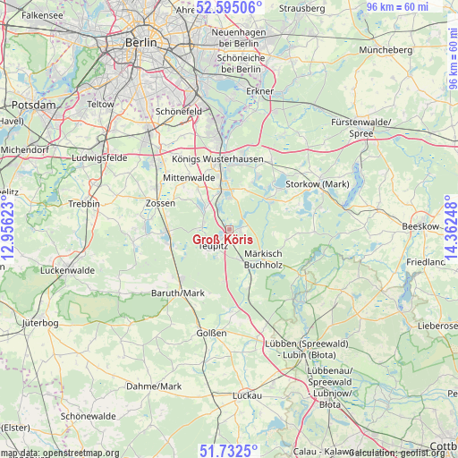
Groß Köris GPS coordinates[2]
52° 9' 57.132" North, 13° 39' 33.66" East
| Map corner | latitude | longitude |
|---|---|---|
| Upper-left | 52.59506°, | 12.95623° |
| Center: | 52.16587°, | 13.65935° |
| Lower-right: | 51.7325°, | 14.36248° |
| Map W x H: | 95.9×95.9 km | = 59.6×59.6mi |
| max Lat: | 55.01917° ⇑26.3% North |
| Groß Köris: | 52.16587° |
| min Lat: | ⇓73.7% South 47.40724° |
| min Long | Groß Köris | max Long |
| 5.92978° | 13.65935° | 14.98853° |
| W 96.6%⇐ | ⇒3.4% E |
Elevation
Elevation of Groß Köris is 37 m = 121 ft, and this is 212.1 m = 696 ft below average elevation for this country.
| Max E: |
1256 m = 4121 ft | 84.1% |
| Avg. | 249.1 m = 817 ft | |
| Groß Köris | 37 m = 121 ft | |
Min E: |
-5 m = -16 ft | 15.9% |
See also: Germany elevation on elevation.city.
Geographical zone
Groß Köris is located in North temperate zone (between Tropic of Cancer and the Arctic Circle). Distance of this North polar circle is 1600.9 km =994.8 mi to North.| Distance of | km | miles | from Groß Köris |
|---|---|---|---|
| North Pole | 4206.8 | 2614 | to North |
| Arctic Circle | 1600.9 | 994.8 | to North |
| Tropic Cancer | 3194.4 | 1984.9 | to South |
| Equator | 5800.3 | 3604.1 | to South |


Nearby cities:
15 places around Groß Köris: (largest is in red/bold)
• Am Mellensee
17.8 km =11.1 mi,  276°
276°
• Baruth
17.2 km =10.7 mi,  218°
218°
• Bestensee
8.4 km =5.2 mi,  349°
349°
• Halbe
6.1 km =3.8 mi,  153°
153°
• Hermsdorf
9.3 km =5.8 mi,  95°
95°
• Königs Wusterhausen
15.2 km =9.4 mi, 353°
• Mittenwalde
13.3 km =8.3 mi,  322°
322°
• Märkisch Buchholz
9.6 km =6 mi,  130°
130°
• Münchehofe
12.1 km =7.5 mi, 99°
• Schwerin
2.5 km =1.6 mi,  225°
225°
• Sperenberg
20.3 km =12.6 mi,  262°
262°
• Teupitz
4.9 km =3 mi,  213°
213°
• Wildau
16.9 km =10.5 mi, 353°
• Zeuthen
20.4 km =12.7 mi, 352°
• Zossen
15.4 km =9.6 mi,  291°
291°
Sources, notices
• [Note1] Compared only with cities in Germany existing in our database
• [Src1] Map data: © OpenStreetMap contributors (CC-BY-SA)
• [Src2] Other city data from geonames.org with taken over terms of usage.
• [Src3] Geographical zone / Annual Mean Temperature by Robert A. Rohde @ Wikipedia
