Storkow geodata
Storkow (Brandenburg) is a populated place; located in Germany in Europe/Berlin (GMT+2) time zone. With population of 9,550 people, there are 1696 cities with bigger population in this country. Compared to other cities in Germany, 74.7% of cities are located further ↓South; 97.7% of cities are located further ←West and 83.2% of cities have higher elevation than Storkow. Note1
Administrative division(s):
- Level 1: Brandenburg
- Level 3: Landkreis Oder-Spree
- Level 4: Storkow (Mark)


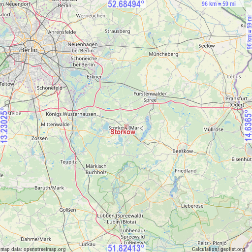
Storkow GPS coordinates[2]
52° 15' 23.832" North, 13° 56' 0.132" East
| Map corner | latitude | longitude |
|---|---|---|
| Upper-left | 52.68494°, | 13.23025° |
| Center: | 52.25662°, | 13.93337° |
| Lower-right: | 51.82413°, | 14.6365° |
| Map W x H: | 95.7×95.7 km | = 59.5×59.5mi |
| max Lat: | 55.01917° ⇑25.3% North |
| Storkow: | 52.25662° |
| min Lat: | ⇓74.7% South 47.40724° |
| min Long | Storkow | max Long |
| 5.92978° | 13.93337° | 14.98853° |
| W 97.7%⇐ | ⇒2.3% E |
Elevation
Elevation of Storkow is 39 m = 128 ft, and this is 210.1 m = 689 ft below average elevation for this country.
| Max E: |
1256 m = 4121 ft | 83.2% |
| Avg. | 249.1 m = 817 ft | |
| Storkow | 39 m = 128 ft | |
Min E: |
-5 m = -16 ft | 16.8% |
See also: Germany elevation on elevation.city.
Geographical zone
Storkow is located in North temperate zone (between Tropic of Cancer and the Arctic Circle). Distance of this North polar circle is 1590.8 km =988.5 mi to North.| Distance of | km | miles | from Storkow |
|---|---|---|---|
| North Pole | 4196.7 | 2607.7 | to North |
| Arctic Circle | 1590.8 | 988.5 | to North |
| Tropic Cancer | 3204.5 | 1991.2 | to South |
| Equator | 5810.4 | 3610.4 | to South |


Nearby cities:
15 places around Storkow: (largest is in red/bold)
• Bad Saarow
9.5 km =5.9 mi,  71°
71°
• Berkenbrück
18 km =11.2 mi,  54°
54°
• Bestensee
20.2 km =12.6 mi,  264°
264°
• Diensdorf-Radlow
8 km =5 mi,  95°
95°
• Fürstenwalde
14.5 km =9 mi,  37°
37°
• Hermsdorf
14.4 km =8.9 mi,  220°
220°
• Langewahl
14.2 km =8.8 mi, 53°
• Märkisch Buchholz
20 km =12.4 mi, 215°
• Münchehofe
13.9 km =8.6 mi,  209°
209°
• Rauen
10.6 km =6.6 mi, 37°
• Reichenwalde
4.7 km =2.9 mi,  76°
76°
• Rietz Neuendorf
16.7 km =10.4 mi, 101°
• Spreenhagen
10.4 km =6.5 mi,  338°
338°
• Tauche
19.8 km =12.3 mi,  126°
126°
• Wendisch Rietz
6.8 km =4.2 mi, 131°
Sources, notices
• [Note1] Compared only with cities in Germany existing in our database
• [Src1] Map data: © OpenStreetMap contributors (CC-BY-SA)
• [Src2] Other city data from geonames.org with taken over terms of usage.
• [Src3] Geographical zone / Annual Mean Temperature by Robert A. Rohde @ Wikipedia
