Hermannsburg geodata
Hermannsburg (Lower Saxony) is a seat of a fourth-order administrative division; located in Germany in Europe/Berlin (GMT+2) time zone. With population of 8,634 people, there are 1851 cities with bigger population in this country. Compared to other cities in Germany, 80.6% of cities are located further ↓South; 51.5% of cities are located further ←West and 77.3% of cities have higher elevation than Hermannsburg. Note1


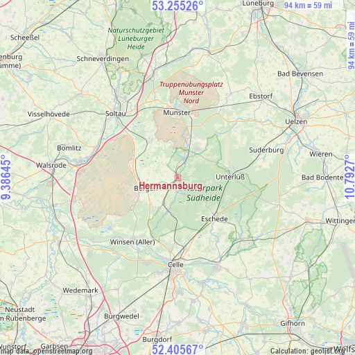
Hermannsburg GPS coordinates[2]
52° 49' 57.144" North, 10° 5' 22.452" East
| Map corner | latitude | longitude |
|---|---|---|
| Upper-left | 53.25526°, | 9.38645° |
| Center: | 52.83254°, | 10.08957° |
| Lower-right: | 52.40567°, | 10.7927° |
| Map W x H: | 94.5×94.5 km | = 58.7×58.7mi |
| max Lat: | 55.01917° ⇑19.4% North |
| Hermannsburg: | 52.83254° |
| min Lat: | ⇓80.6% South 47.40724° |
| min Long | Hermannsburg | max Long |
| 5.92978° | 10.08957° | 14.98853° |
| W 51.5%⇐ | ⇒48.5% E |
Elevation
Elevation of Hermannsburg is 55 m = 180 ft, and this is 194.1 m = 637 ft below average elevation for this country.
| Max E: |
1256 m = 4121 ft | 77.3% |
| Avg. | 249.1 m = 817 ft | |
| Hermannsburg | 55 m = 180 ft | |
Min E: |
-5 m = -16 ft | 22.7% |
See also: Germany elevation on elevation.city.
Geographical zone
Hermannsburg is located in North temperate zone (between Tropic of Cancer and the Arctic Circle). Distance of this North polar circle is 1526.7 km =948.6 mi to North.| Distance of | km | miles | from Hermannsburg |
|---|---|---|---|
| North Pole | 4132.6 | 2567.9 | to North |
| Arctic Circle | 1526.7 | 948.6 | to North |
| Tropic Cancer | 3268.5 | 2031 | to South |
| Equator | 5874.4 | 3650.2 | to South |


Nearby cities:
15 places around Hermannsburg: (largest is in red/bold)
• Bergen
8.9 km =5.5 mi,  252°
252°
• Celle
23.3 km =14.5 mi,  181°
181°
• Eimke
21.1 km =13.1 mi,  45°
45°
• Eldingen
23.3 km =14.5 mi,  135°
135°
• Eschede
14.6 km =9.1 mi, 137°
• Faßberg
9.1 km =5.7 mi,  34°
34°
• Habighorst
16.6 km =10.3 mi,  146°
146°
• Hambühren
23.3 km =14.5 mi,  197°
197°
• Höfer
19.8 km =12.3 mi, 146°
• Munster
17 km =10.6 mi,  359°
359°
• Scharnhorst
18.3 km =11.4 mi,  134°
134°
• Unterlüß
13.9 km =8.6 mi,  89°
89°
• Wietzendorf
11.8 km =7.3 mi,  322°
322°
• Winsen
20.4 km =12.7 mi,  215°
215°
• Winsen (Aller)
20.5 km =12.7 mi, 216°
Sources, notices
• [Note1] Compared only with cities in Germany existing in our database
• [Src1] Map data: © OpenStreetMap contributors (CC-BY-SA)
• [Src2] Other city data from geonames.org with taken over terms of usage.
• [Src3] Geographical zone / Annual Mean Temperature by Robert A. Rohde @ Wikipedia
