Faßberg geodata
Faßberg (Lower Saxony) is a seat of a fourth-order administrative division; located in Germany in Europe/Berlin (GMT+2) time zone. With population of 7,299 people, there are 2117 cities with bigger population in this country. Compared to other cities in Germany, 81% of cities are located further ↓South; 52.7% of cities are located further ←West and 74.1% of cities have higher elevation than Faßberg. Note1


Faßberg GPS coordinates[2]
52° 54' 0" North, 10° 10' 0.012" East
| Map corner | latitude | longitude |
|---|---|---|
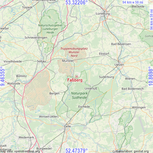
| Upper-left | 53.32206°, | 9.46355° |
| Center: | 52.9°, | 10.16667° |
| Lower-right: | 52.47379°, | 10.8698° |
| Map W x H: | 94.3×94.3 km | = 58.6×58.6mi |
| max Lat: | 55.01917° ⇑19% North |
| Faßberg: | 52.9° |
| min Lat: | ⇓81% South 47.40724° |
| min Long | Faßberg | max Long |
| 5.92978° | 10.16667° | 14.98853° |
| W 52.7%⇐ | ⇒47.3% E |
Elevation
Elevation of Faßberg is 67 m = 220 ft, and this is 182.1 m = 597 ft below average elevation for this country.
| Max E: |
1256 m = 4121 ft | 74.1% |
| Avg. | 249.1 m = 817 ft | |
| Faßberg | 67 m = 220 ft | |
Min E: |
-5 m = -16 ft | 25.9% |
See also: Germany elevation on elevation.city.
Geographical zone
Faßberg is located in North temperate zone (between Tropic of Cancer and the Arctic Circle). Distance of this North polar circle is 1519.2 km =944 mi to North.| Distance of | km | miles | from Faßberg |
|---|---|---|---|
| North Pole | 4125.1 | 2563.2 | to North |
| Arctic Circle | 1519.2 | 944 | to North |
| Tropic Cancer | 3276 | 2035.6 | to South |
| Equator | 5881.9 | 3654.8 | to South |


Nearby cities:
15 places around Faßberg: (largest is in red/bold)
• Bergen
17 km =10.6 mi,  233°
233°
• Ebstorf
22.1 km =13.7 mi,  49°
49°
• Eimke
12.3 km =7.6 mi, 53°
• Eschede
18.9 km =11.7 mi,  165°
165°
• Gerdau
18.3 km =11.4 mi,  66°
66°
• Habighorst
21.7 km =13.5 mi, 169°
• Hanstedt Eins
21.4 km =13.3 mi,  40°
40°
• Hermannsburg
9.1 km =5.7 mi,  214°
214°
• Munster
10.9 km =6.8 mi,  330°
330°
• Scharnhorst
21.8 km =13.5 mi,  158°
158°
• Schwienau
22.1 km =13.7 mi,  57°
57°
• Suderburg
19.1 km =11.9 mi,  91°
91°
• Unterlüß
11.4 km =7.1 mi,  129°
129°
• Wietzendorf
12.4 km =7.7 mi,  278°
278°
• Wriedel
17.1 km =10.6 mi,  31°
31°
Sources, notices
• [Note1] Compared only with cities in Germany existing in our database
• [Src1] Map data: © OpenStreetMap contributors (CC-BY-SA)
• [Src2] Other city data from geonames.org with taken over terms of usage.
• [Src3] Geographical zone / Annual Mean Temperature by Robert A. Rohde @ Wikipedia
