Celle geodata
Celle (Lower Saxony) is a seat of a third-order administrative division; located in Germany in Europe/Berlin (GMT+2) time zone. With population of 71,010 people, there are 147 cities with bigger population in this country. Compared to other cities in Germany, 79% of cities are located further ↓South; 51.4% of cities are located further ←West and 80.6% of cities have higher elevation than Celle. Note1


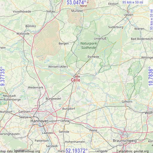
Celle GPS coordinates[2]
52° 37' 21.504" North, 10° 4' 49.692" East
| Map corner | latitude | longitude |
|---|---|---|
| Upper-left | 53.0474°, | 9.37735° |
| Center: | 52.62264°, | 10.08047° |
| Lower-right: | 52.19372°, | 10.7836° |
| Map W x H: | 94.9×94.9 km | = 59×59mi |
| max Lat: | 55.01917° ⇑21% North |
| Celle: | 52.62264° |
| min Lat: | ⇓79% South 47.40724° |
| min Long | Celle | max Long |
| 5.92978° | 10.08047° | 14.98853° |
| W 51.4%⇐ | ⇒48.6% E |
Elevation
Elevation of Celle is 45 m = 148 ft, and this is 204.1 m = 670 ft below average elevation for this country.
| Max E: |
1256 m = 4121 ft | 80.6% |
| Avg. | 249.1 m = 817 ft | |
| Celle | 45 m = 148 ft | |
Min E: |
-5 m = -16 ft | 19.4% |
See also: Celle elevation on elevation.city.
Geographical zone
Celle is located in North temperate zone (between Tropic of Cancer and the Arctic Circle). Distance of this North polar circle is 1550.1 km =963.2 mi to North.| Distance of | km | miles | from Celle |
|---|---|---|---|
| North Pole | 4156 | 2582.4 | to North |
| Arctic Circle | 1550.1 | 963.2 | to North |
| Tropic Cancer | 3245.2 | 2016.5 | to South |
| Equator | 5851.1 | 3635.7 | to South |


Nearby cities:
15 places around Celle: (largest is in red/bold)
• Adelheidsdorf
6.7 km =4.2 mi,  191°
191°
• Ahnsbeck
13.9 km =8.6 mi,  95°
95°
• Beedenbostel
12.3 km =7.6 mi,  79°
79°
• Bröckel
14.9 km =9.3 mi,  142°
142°
• Eicklingen
10.7 km =6.6 mi, 138°
• Habighorst
13.8 km =8.6 mi,  46°
46°
• Hambühren
6.7 km =4.2 mi,  280°
280°
• Hänigsen
15.4 km =9.6 mi,  177°
177°
• Höfer
13.3 km =8.3 mi,  59°
59°
• Lachendorf
11.5 km =7.1 mi,  93°
93°
• Nienhagen
7.4 km =4.6 mi,  168°
168°
• Wathlingen
10.6 km =6.6 mi,  153°
153°
• Wienhausen
8.7 km =5.4 mi,  122°
122°
• Winsen
13.1 km =8.1 mi,  300°
300°
• Winsen (Aller)
13.4 km =8.3 mi, 300°
Sources, notices
• [Note1] Compared only with cities in Germany existing in our database
• [Src1] Map data: © OpenStreetMap contributors (CC-BY-SA)
• [Src2] Other city data from geonames.org with taken over terms of usage.
• [Src3] Geographical zone / Annual Mean Temperature by Robert A. Rohde @ Wikipedia
