Höhn geodata
Höhn (Rheinland-Pfalz) is a seat of a fourth-order administrative division; located in Germany in Europe/Berlin (GMT+2) time zone. With population of 3,238 people, there are 3799 cities with bigger population in this country. Compared to other cities in Germany, 50.2% of cities are located further ↑North; 77.5% of cities are located further →East and 89.4% of cities have lower elevation than Höhn. Note1


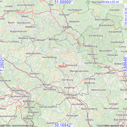
Höhn GPS coordinates[2]
50° 37' 0.012" North, 7° 58' 59.988" East
| Map corner | latitude | longitude |
|---|---|---|
| Upper-left | 51.06069°, | 7.28021° |
| Center: | 50.61667°, | 7.98333° |
| Lower-right: | 50.16842°, | 8.68646° |
| Map W x H: | 99.2×99.2 km | = 61.6×61.6mi |
| max Lat: | 55.01917° ⇑50.2% North |
| Höhn: | 50.61667° |
| min Lat: | ⇓49.8% South 47.40724° |
| min Long | Höhn | max Long |
| 5.92978° | 7.98333° | 14.98853° |
| W 22.5%⇐ | ⇒77.5% E |
Elevation
Elevation of Höhn is 507 m = 1663 ft, and this is 257.9 m = 846 ft above average elevation for this country.
| Max E: |
1256 m = 4121 ft | 10.6% |
| Höhn | 507 m 1663 ft | |
| Avg. | 249.1 m = 817 ft | |
Min E: |
-5 m = -16 ft | 89.4% |
See also: Germany elevation on elevation.city.
Geographical zone
Höhn is located in North temperate zone (between Tropic of Cancer and the Arctic Circle). Distance of this North polar circle is 1773.1 km =1101.8 mi to North.| Distance of | km | miles | from Höhn |
|---|---|---|---|
| North Pole | 4379 | 2721 | to North |
| Arctic Circle | 1773.1 | 1101.8 | to North |
| Tropic Cancer | 3022.1 | 1877.8 | to South |
| Equator | 5628 | 3497.1 | to South |


Nearby cities:
15 places around Höhn: (largest is in red/bold)
• Ailertchen
3.5 km =2.2 mi,  235°
235°
• Bad Marienberg
4.4 km =2.7 mi,  326°
326°
• Dreisbach
3.5 km =2.2 mi,  270°
270°
• Fehl-Ritzhausen
3.4 km =2.1 mi,  23°
23°
• Großseifen
2.2 km =1.4 mi, 327°
• Hahn bei Marienberg
3.5 km =2.2 mi,  301°
301°
• Halbs
3.2 km =2 mi,  204°
204°
• Hardt
5.1 km =3.2 mi,  291°
291°
• Hellenhahn-Schellenberg
3.1 km =1.9 mi,  98°
98°
• Hergenroth
3.8 km =2.4 mi,  189°
189°
• Langenbach bei Marienberg
3.5 km =2.2 mi,  313°
313°
• Neustadt/Westerwald
4.3 km =2.7 mi,  70°
70°
• Niederroßbach
4.6 km =2.9 mi,  52°
52°
• Pottum
2.2 km =1.4 mi,  147°
147°
• Stockhausen-Illfurth
3.3 km =2.1 mi,  5°
5°
Sources, notices
• [Note1] Compared only with cities in Germany existing in our database
• [Src1] Map data: © OpenStreetMap contributors (CC-BY-SA)
• [Src2] Other city data from geonames.org with taken over terms of usage.
• [Src3] Geographical zone / Annual Mean Temperature by Robert A. Rohde @ Wikipedia
