Blankenheim geodata
Blankenheim (Saxony-Anhalt) is a seat of a fourth-order administrative division; located in Germany in Europe/Berlin (GMT+2) time zone. With population of 1,436 people, there are 6005 cities with bigger population in this country. Compared to other cities in Germany, 66.5% of cities are located further ↓South; 73.1% of cities are located further ←West and 61.2% of cities have lower elevation than Blankenheim. Note1


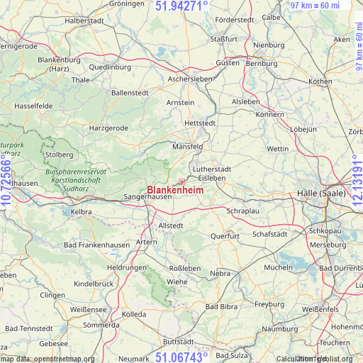
Blankenheim GPS coordinates[2]
51° 30' 25.812" North, 11° 25' 43.608" East
| Map corner | latitude | longitude |
|---|---|---|
| Upper-left | 51.94271°, | 10.72566° |
| Center: | 51.50717°, | 11.42878° |
| Lower-right: | 51.06743°, | 12.13191° |
| Map W x H: | 97.3×97.3 km | = 60.5×60.5mi |
| max Lat: | 55.01917° ⇑33.5% North |
| Blankenheim: | 51.50717° |
| min Lat: | ⇓66.5% South 47.40724° |
| min Long | Blankenheim | max Long |
| 5.92978° | 11.42878° | 14.98853° |
| W 73.1%⇐ | ⇒26.9% E |
Elevation
Elevation of Blankenheim is 297 m = 974 ft, and this is 47.9 m = 157 ft above average elevation for this country.
| Max E: |
1256 m = 4121 ft | 38.8% |
| Blankenheim | 297 m 974 ft | |
| Avg. | 249.1 m = 817 ft | |
Min E: |
-5 m = -16 ft | 61.2% |
See also: Germany elevation on elevation.city.
Geographical zone
Blankenheim is located in North temperate zone (between Tropic of Cancer and the Arctic Circle). Distance of this North polar circle is 1674.1 km =1040.2 mi to North.| Distance of | km | miles | from Blankenheim |
|---|---|---|---|
| North Pole | 4280 | 2659.5 | to North |
| Arctic Circle | 1674.1 | 1040.2 | to North |
| Tropic Cancer | 3121.1 | 1939.4 | to South |
| Equator | 5727.1 | 3558.7 | to South |


Nearby cities:
15 places around Blankenheim: (largest is in red/bold)
• Ahlsdorf
5 km =3.1 mi,  31°
31°
• Annarode
5.1 km =3.2 mi,  339°
339°
• Beyernaumburg
4.4 km =2.7 mi,  212°
212°
• Bischofrode
7.5 km =4.7 mi,  107°
107°
• Bornstedt
4.6 km =2.9 mi,  125°
125°
• Emseloh
2.6 km =1.6 mi,  256°
256°
• Gonna
7.3 km =4.5 mi,  271°
271°
• Helbra
6.9 km =4.3 mi,  45°
45°
• Hergisdorf
4.8 km =3 mi, 52°
• Holdenstedt
3.7 km =2.3 mi,  161°
161°
• Obersdorf
7.3 km =4.5 mi,  282°
282°
• Riestedt
4.9 km =3 mi,  254°
254°
• Siebigerode
6.4 km =4 mi,  359°
359°
• Wimmelburg
5.6 km =3.5 mi,  74°
74°
• Wolferode
5.8 km =3.6 mi,  90°
90°
Sources, notices
• [Note1] Compared only with cities in Germany existing in our database
• [Src1] Map data: © OpenStreetMap contributors (CC-BY-SA)
• [Src2] Other city data from geonames.org with taken over terms of usage.
• [Src3] Geographical zone / Annual Mean Temperature by Robert A. Rohde @ Wikipedia
