Neuhausen geodata
Neuhausen (Baden-Württemberg) is a seat of a fourth-order administrative division; located in Germany in Europe/Berlin (GMT+2) time zone. With population of 5,475 people, there are 2636 cities with bigger population in this country. Compared to other cities in Germany, 85.5% of cities are located further ↑North; 68.2% of cities are located further →East and 87.7% of cities have lower elevation than Neuhausen. Note1
Administrative division(s):
- Level 1: Baden-Württemberg
- Level 2: Karlsruhe Region
- Level 3: Enzkreis
- Level 4: Neuhausen


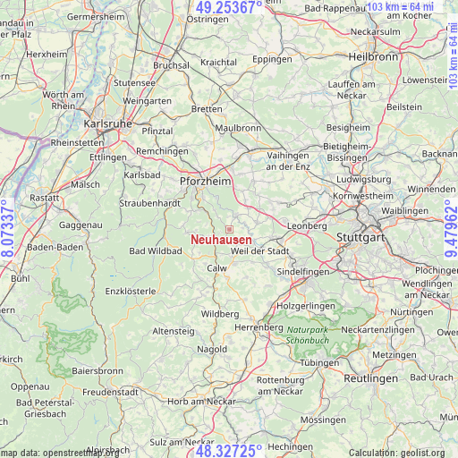
Neuhausen GPS coordinates[2]
48° 47' 33.36" North, 8° 46' 35.364" East
| Map corner | latitude | longitude |
|---|---|---|
| Upper-left | 49.25367°, | 8.07337° |
| Center: | 48.7926°, | 8.77649° |
| Lower-right: | 48.32725°, | 9.47962° |
| Map W x H: | 103×103 km | = 64×64mi |
| max Lat: | 55.01917° ⇑85.5% North |
| Neuhausen: | 48.7926° |
| min Lat: | ⇓14.5% South 47.40724° |
| min Long | Neuhausen | max Long |
| 5.92978° | 8.77649° | 14.98853° |
| W 31.8%⇐ | ⇒68.2% E |
Elevation
Elevation of Neuhausen is 491 m = 1611 ft, and this is 241.9 m = 794 ft above average elevation for this country.
| Max E: |
1256 m = 4121 ft | 12.3% |
| Neuhausen | 491 m 1611 ft | |
| Avg. | 249.1 m = 817 ft | |
Min E: |
-5 m = -16 ft | 87.7% |
See also: Germany elevation on elevation.city.
Geographical zone
Neuhausen is located in North temperate zone (between Tropic of Cancer and the Arctic Circle). Distance of this North polar circle is 1975.9 km =1227.8 mi to North.| Distance of | km | miles | from Neuhausen |
|---|---|---|---|
| North Pole | 4581.8 | 2847 | to North |
| Arctic Circle | 1975.9 | 1227.8 | to North |
| Tropic Cancer | 2819.3 | 1751.8 | to South |
| Equator | 5425.2 | 3371.1 | to South |


Nearby cities:
15 places around Neuhausen: (largest is in red/bold)
• Althengstett
7.8 km =4.8 mi,  170°
170°
• Bad Liebenzell
4 km =2.5 mi,  239°
239°
• Calw
9.1 km =5.7 mi,  196°
196°
• Engelsbrand
10.3 km =6.4 mi,  296°
296°
• Friolzheim
6.2 km =3.9 mi,  42°
42°
• Heimsheim
6.8 km =4.2 mi,  76°
76°
• Oberreichenbach
10.4 km =6.5 mi,  230°
230°
• Ostelsheim
9 km =5.6 mi,  144°
144°
• Schömberg
9.7 km =6 mi,  266°
266°
• Simmozheim
5.3 km =3.3 mi,  150°
150°
• Tiefenbronn
3.9 km =2.4 mi,  27°
27°
• Unterreichenbach
6.1 km =3.8 mi,  305°
305°
• Weil der Stadt
8.5 km =5.3 mi,  124°
124°
• Wimsheim
7.6 km =4.7 mi, 33°
• Wurmberg
8.7 km =5.4 mi,  19°
19°
Sources, notices
• [Note1] Compared only with cities in Germany existing in our database
• [Src1] Map data: © OpenStreetMap contributors (CC-BY-SA)
• [Src2] Other city data from geonames.org with taken over terms of usage.
• [Src3] Geographical zone / Annual Mean Temperature by Robert A. Rohde @ Wikipedia
