Heimbuchenthal geodata
Heimbuchenthal (Bavaria) is a seat of a fourth-order administrative division; located in Germany in Europe/Berlin (GMT+2) time zone. With population of 2,219 people, there are 4783 cities with bigger population in this country. Compared to other cities in Germany, 66.8% of cities are located further ↑North; 60.8% of cities are located further →East and 50.6% of cities have lower elevation than Heimbuchenthal. Note1
Administrative division(s):
- Level 1: Bavaria
- Level 2: Regierungsbezirk Unterfranken
- Level 3: Landkreis Aschaffenburg
- Level 4: Heimbuchenthal


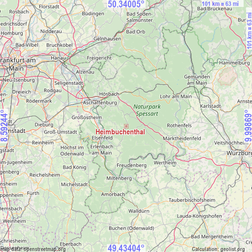
Heimbuchenthal GPS coordinates[2]
49° 53' 21.012" North, 9° 17' 44.016" East
| Map corner | latitude | longitude |
|---|---|---|
| Upper-left | 50.34005°, | 8.59244° |
| Center: | 49.88917°, | 9.29556° |
| Lower-right: | 49.43404°, | 9.99869° |
| Map W x H: | 100.7×100.7 km | = 62.6×62.6mi |
| max Lat: | 55.01917° ⇑66.8% North |
| Heimbuchenthal: | 49.88917° |
| min Lat: | ⇓33.2% South 47.40724° |
| min Long | Heimbuchenthal | max Long |
| 5.92978° | 9.29556° | 14.98853° |
| W 39.2%⇐ | ⇒60.8% E |
Elevation
Elevation of Heimbuchenthal is 230 m = 755 ft, and this is 19.1 m = 63 ft below average elevation for this country.
| Max E: |
1256 m = 4121 ft | 49.4% |
| Avg. | 249.1 m = 817 ft | |
| Heimbuchenthal | 230 m = 755 ft | |
Min E: |
-5 m = -16 ft | 50.6% |
See also: Germany elevation on elevation.city.
Geographical zone
Heimbuchenthal is located in North temperate zone (between Tropic of Cancer and the Arctic Circle). Distance of this North polar circle is 1854 km =1152 mi to North.| Distance of | km | miles | from Heimbuchenthal |
|---|---|---|---|
| North Pole | 4459.9 | 2771.3 | to North |
| Arctic Circle | 1854 | 1152 | to North |
| Tropic Cancer | 2941.2 | 1827.6 | to South |
| Equator | 5547.2 | 3446.9 | to South |


Nearby cities:
15 places around Heimbuchenthal: (largest is in red/bold)
• Altenbuch
10.1 km =6.3 mi,  131°
131°
• Elsenfeld
10.8 km =6.7 mi,  241°
241°
• Eschau
8.2 km =5.1 mi,  198°
198°
• Großwallstadt
10.2 km =6.3 mi,  263°
263°
• Haibach
10.5 km =6.5 mi,  322°
322°
• Hausen
6.5 km =4 mi,  250°
250°
• Kleinwallstadt
9.2 km =5.7 mi, 259°
• Leidersbach
5.5 km =3.4 mi,  284°
284°
• Mespelbrunn
2.8 km =1.7 mi,  354°
354°
• Mönchberg
10.8 km =6.7 mi,  190°
190°
• Niedernberg
11.6 km =7.2 mi, 282°
• Rothenbuch
11 km =6.8 mi,  39°
39°
• Sulzbach am Main
10.5 km =6.5 mi, 283°
• Waldaschaff
9.6 km =6 mi,  2°
2°
• Weibersbrunn
6.9 km =4.3 mi,  47°
47°
Sources, notices
• [Note1] Compared only with cities in Germany existing in our database
• [Src1] Map data: © OpenStreetMap contributors (CC-BY-SA)
• [Src2] Other city data from geonames.org with taken over terms of usage.
• [Src3] Geographical zone / Annual Mean Temperature by Robert A. Rohde @ Wikipedia
