Heiligenstadt geodata
Heiligenstadt (Bavaria) is a populated place; located in Germany in Europe/Berlin (GMT+2) time zone. With population of 3,690 people, there are 3484 cities with bigger population in this country. Compared to other cities in Germany, 67.5% of cities are located further ↑North; 69.5% of cities are located further ←West and 69.7% of cities have lower elevation than Heiligenstadt. Note1
Administrative division(s):
- Level 1: Bavaria
- Level 2: Upper Franconia
- Level 3: Landkreis Bamberg
- Level 4: Heiligenstadt i.OFr., Markt


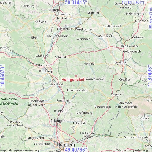
Heiligenstadt GPS coordinates[2]
49° 51' 46.908" North, 11° 10' 18.66" East
| Map corner | latitude | longitude |
|---|---|---|
| Upper-left | 50.31415°, | 10.46873° |
| Center: | 49.86303°, | 11.17185° |
| Lower-right: | 49.40766°, | 11.87498° |
| Map W x H: | 100.8×100.8 km | = 62.6×62.6mi |
| max Lat: | 55.01917° ⇑67.5% North |
| Heiligenstadt: | 49.86303° |
| min Lat: | ⇓32.5% South 47.40724° |
| min Long | Heiligenstadt | max Long |
| 5.92978° | 11.17185° | 14.98853° |
| W 69.5%⇐ | ⇒30.5% E |
Elevation
Elevation of Heiligenstadt is 356 m = 1168 ft, and this is 106.9 m = 351 ft above average elevation for this country.
| Max E: |
1256 m = 4121 ft | 30.3% |
| Heiligenstadt | 356 m 1168 ft | |
| Avg. | 249.1 m = 817 ft | |
Min E: |
-5 m = -16 ft | 69.7% |
See also: Germany elevation on elevation.city.
Geographical zone
Heiligenstadt is located in North temperate zone (between Tropic of Cancer and the Arctic Circle). Distance of this North polar circle is 1856.9 km =1153.8 mi to North.| Distance of | km | miles | from Heiligenstadt |
|---|---|---|---|
| North Pole | 4462.8 | 2773.1 | to North |
| Arctic Circle | 1856.9 | 1153.8 | to North |
| Tropic Cancer | 2938.3 | 1825.8 | to South |
| Equator | 5544.2 | 3445 | to South |


Nearby cities:
15 places around Heiligenstadt: (largest is in red/bold)
• Altendorf
13.2 km =8.2 mi,  237°
237°
• Aufseß
4.6 km =2.9 mi,  59°
59°
• Buttenheim
12.1 km =7.5 mi, 237°
• Ebermannstadt
9.1 km =5.7 mi,  175°
175°
• Eggolsheim
13.3 km =8.3 mi,  218°
218°
• Hirschaid
14 km =8.7 mi,  249°
249°
• Hollfeld
12 km =7.5 mi,  45°
45°
• Königsfeld
9.2 km =5.7 mi,  357°
357°
• Litzendorf
12.9 km =8 mi,  296°
296°
• Plankenfels
11.8 km =7.3 mi,  78°
78°
• Poxdorf
8.9 km =5.5 mi,  336°
336°
• Pretzfeld
12.1 km =7.5 mi, 179°
• Unterleinleiter
4.6 km =2.9 mi,  164°
164°
• Waischenfeld
12.8 km =8 mi,  98°
98°
• Weilersbach
13.2 km =8.2 mi,  197°
197°
Sources, notices
• [Note1] Compared only with cities in Germany existing in our database
• [Src1] Map data: © OpenStreetMap contributors (CC-BY-SA)
• [Src2] Other city data from geonames.org with taken over terms of usage.
• [Src3] Geographical zone / Annual Mean Temperature by Robert A. Rohde @ Wikipedia
