Litzendorf geodata
Litzendorf (Bavaria) is a seat of a fourth-order administrative division; located in Germany in Europe/Berlin (GMT+2) time zone. With population of 6,101 people, there are 2431 cities with bigger population in this country. Compared to other cities in Germany, 66.1% of cities are located further ↑North; 67.1% of cities are located further ←West and 64.5% of cities have lower elevation than Litzendorf. Note1
Administrative division(s):
- Level 1: Bavaria
- Level 2: Upper Franconia
- Level 3: Landkreis Bamberg
- Level 4: Litzendorf


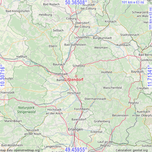
Litzendorf GPS coordinates[2]
49° 54' 51.984" North, 11° 0' 37.008" East
| Map corner | latitude | longitude |
|---|---|---|
| Upper-left | 50.36508°, | 10.30716° |
| Center: | 49.91444°, | 11.01028° |
| Lower-right: | 49.45955°, | 11.71341° |
| Map W x H: | 100.7×100.7 km | = 62.6×62.6mi |
| max Lat: | 55.01917° ⇑66.1% North |
| Litzendorf: | 49.91444° |
| min Lat: | ⇓33.9% South 47.40724° |
| min Long | Litzendorf | max Long |
| 5.92978° | 11.01028° | 14.98853° |
| W 67.1%⇐ | ⇒32.9% E |
Elevation
Elevation of Litzendorf is 318 m = 1043 ft, and this is 68.9 m = 226 ft above average elevation for this country.
| Max E: |
1256 m = 4121 ft | 35.5% |
| Litzendorf | 318 m 1043 ft | |
| Avg. | 249.1 m = 817 ft | |
Min E: |
-5 m = -16 ft | 64.5% |
See also: Germany elevation on elevation.city.
Geographical zone
Litzendorf is located in North temperate zone (between Tropic of Cancer and the Arctic Circle). Distance of this North polar circle is 1851.2 km =1150.3 mi to North.| Distance of | km | miles | from Litzendorf |
|---|---|---|---|
| North Pole | 4457.1 | 2769.5 | to North |
| Arctic Circle | 1851.2 | 1150.3 | to North |
| Tropic Cancer | 2944 | 1829.3 | to South |
| Equator | 5550 | 3448.6 | to South |


Nearby cities:
15 places around Litzendorf: (largest is in red/bold)
• Altendorf
12.7 km =7.9 mi,  177°
177°
• Bamberg
8 km =5 mi,  257°
257°
• Bischberg
12.8 km =8 mi,  268°
268°
• Breitengüßbach
11 km =6.8 mi,  305°
305°
• Buttenheim
12.4 km =7.7 mi,  173°
173°
• Gundelsheim
6.9 km =4.3 mi,  291°
291°
• Hallstadt
9.8 km =6.1 mi,  279°
279°
• Hirschaid
10.8 km =6.7 mi,  188°
188°
• Kemmern
10.5 km =6.5 mi,  295°
295°
• Königsfeld
11.6 km =7.2 mi,  72°
72°
• Memmelsdorf
4.1 km =2.5 mi, 295°
• Pettstadt
11.1 km =6.9 mi,  211°
211°
• Poxdorf
8.4 km =5.2 mi, 73°
• Scheßlitz
7 km =4.3 mi,  13°
13°
• Strullendorf
8.3 km =5.2 mi,  199°
199°
Sources, notices
• [Note1] Compared only with cities in Germany existing in our database
• [Src1] Map data: © OpenStreetMap contributors (CC-BY-SA)
• [Src2] Other city data from geonames.org with taken over terms of usage.
• [Src3] Geographical zone / Annual Mean Temperature by Robert A. Rohde @ Wikipedia
