Aufseß geodata
Aufseß (Bavaria) is a seat of a fourth-order administrative division; located in Germany in Europe/Berlin (GMT+2) time zone. With population of 1,410 people, there are 6060 cities with bigger population in this country. Compared to other cities in Germany, 66.8% of cities are located further ↑North; 70.3% of cities are located further ←West and 76.8% of cities have lower elevation than Aufseß. Note1
Administrative division(s):
- Level 1: Bavaria
- Level 2: Upper Franconia
- Level 3: Landkreis Bayreuth
- Level 4: Aufseß


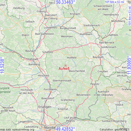
Aufseß GPS coordinates[2]
49° 53' 1.32" North, 11° 13' 36.912" East
| Map corner | latitude | longitude |
|---|---|---|
| Upper-left | 50.33463°, | 10.5238° |
| Center: | 49.8837°, | 11.22692° |
| Lower-right: | 49.42852°, | 11.93005° |
| Map W x H: | 100.7×100.7 km | = 62.6×62.6mi |
| max Lat: | 55.01917° ⇑66.8% North |
| Aufseß: | 49.8837° |
| min Lat: | ⇓33.2% South 47.40724° |
| min Long | Aufseß | max Long |
| 5.92978° | 11.22692° | 14.98853° |
| W 70.3%⇐ | ⇒29.7% E |
Elevation
Elevation of Aufseß is 411 m = 1348 ft, and this is 161.9 m = 531 ft above average elevation for this country.
| Max E: |
1256 m = 4121 ft | 23.2% |
| Aufseß | 411 m 1348 ft | |
| Avg. | 249.1 m = 817 ft | |
Min E: |
-5 m = -16 ft | 76.8% |
See also: Germany elevation on elevation.city.
Geographical zone
Aufseß is located in North temperate zone (between Tropic of Cancer and the Arctic Circle). Distance of this North polar circle is 1854.6 km =1152.4 mi to North.| Distance of | km | miles | from Aufseß |
|---|---|---|---|
| North Pole | 4460.5 | 2771.6 | to North |
| Arctic Circle | 1854.6 | 1152.4 | to North |
| Tropic Cancer | 2940.6 | 1827.2 | to South |
| Equator | 5546.5 | 3446.4 | to South |


Nearby cities:
15 places around Aufseß: (largest is in red/bold)
• Buttenheim
16.7 km =10.4 mi,  237°
237°
• Ebermannstadt
11.8 km =7.3 mi,  195°
195°
• Glashütten
15.9 km =9.9 mi,  88°
88°
• Gößweinstein
15.1 km =9.4 mi,  147°
147°
• Heiligenstadt
4.6 km =2.9 mi, 239°
• Hollfeld
7.6 km =4.7 mi,  37°
37°
• Königsfeld
8.2 km =5.1 mi,  327°
327°
• Litzendorf
15.9 km =9.9 mi,  282°
282°
• Plankenfels
7.6 km =4.7 mi, 90°
• Poxdorf
9.5 km =5.9 mi,  307°
307°
• Pretzfeld
14.8 km =9.2 mi,  194°
194°
• Stadelhofen
13.4 km =8.3 mi,  351°
351°
• Unterleinleiter
7.3 km =4.5 mi, 201°
• Waischenfeld
9.6 km =6 mi,  115°
115°
• Wonsees
11.5 km =7.1 mi,  27°
27°
Sources, notices
• [Note1] Compared only with cities in Germany existing in our database
• [Src1] Map data: © OpenStreetMap contributors (CC-BY-SA)
• [Src2] Other city data from geonames.org with taken over terms of usage.
• [Src3] Geographical zone / Annual Mean Temperature by Robert A. Rohde @ Wikipedia
