Burg auf Fehmarn geodata
Burg auf Fehmarn (Schleswig-Holstein) is a section of populated place; located in Germany in Europe/Berlin (GMT+2) time zone. With population of 6,000 people, there are 2462 cities with bigger population in this country. Compared to other cities in Germany, 97.6% of cities are located further ↓South; 69.9% of cities are located further ←West and 94.8% of cities have higher elevation than Burg auf Fehmarn. Note1


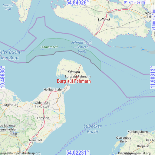
Burg auf Fehmarn GPS coordinates[2]
54° 25' 59.988" North, 11° 12' 0" East
| Map corner | latitude | longitude |
|---|---|---|
| Upper-left | 54.84026°, | 10.49688° |
| Center: | 54.43333°, | 11.2° |
| Lower-right: | 54.02231°, | 11.90313° |
| Map W x H: | 90.9×90.9 km | = 56.5×56.5mi |
| max Lat: | 55.01917° ⇑2.4% North |
| Burg auf Fehmarn: | 54.43333° |
| min Lat: | ⇓97.6% South 47.40724° |
| min Long | Burg auf Fehmar | max Long |
| 5.92978° | 11.2° | 14.98853° |
| W 69.9%⇐ | ⇒30.1% E |
Elevation
Elevation of Burg auf Fehmarn is 9 m = 30 ft, and this is 240.1 m = 788 ft below average elevation for this country.
| Max E: |
1256 m = 4121 ft | 94.8% |
| Avg. | 249.1 m = 817 ft | |
| Burg auf Fehmarn | 9 m = 30 ft | |
Min E: |
-5 m = -16 ft | 5.2% |
See also: Germany elevation on elevation.city.
Geographical zone
Burg auf Fehmarn is located in North temperate zone (between Tropic of Cancer and the Arctic Circle). Distance of this North polar circle is 1348.8 km =838.1 mi to North.| Distance of | km | miles | from Burg auf Fehmarn |
|---|---|---|---|
| North Pole | 3954.6 | 2457.3 | to North |
| Arctic Circle | 1348.8 | 838.1 | to North |
| Tropic Cancer | 3446.5 | 2141.6 | to South |
| Equator | 6052.4 | 3760.8 | to South |


Nearby cities:
15 places around Burg auf Fehmarn: (largest is in red/bold)
• Dahme
25.3 km =15.7 mi,  197°
197°
• Damlos
28.2 km =17.5 mi,  223°
223°
• Fehmarn
0.7 km =0.4 mi,  319°
319°
• Goel
23.7 km =14.7 mi,  225°
225°
• Gremersdorf
20.5 km =12.7 mi,  237°
237°
• Grossenbrode
9.4 km =5.8 mi, 233°
• Grube
24.7 km =15.3 mi,  205°
205°
• Heiligenhafen
15.9 km =9.9 mi, 243°
• Heringsdorf
19.3 km =12 mi, 220°
• Kabelhorst
30.3 km =18.8 mi, 217°
• Kellenhusen
28.1 km =17.5 mi, 198°
• Lensahn
31.7 km =19.7 mi, 220°
• Neukirchen
17.1 km =10.6 mi, 224°
• Oldenburg in Holstein
24.7 km =15.3 mi, 231°
• Riepsdorf
27.4 km =17 mi, 212°
Sources, notices
• [Note1] Compared only with cities in Germany existing in our database
• [Src1] Map data: © OpenStreetMap contributors (CC-BY-SA)
• [Src2] Other city data from geonames.org with taken over terms of usage.
• [Src3] Geographical zone / Annual Mean Temperature by Robert A. Rohde @ Wikipedia
