Handeloh geodata
Handeloh (Lower Saxony) is a seat of a fourth-order administrative division; located in Germany in Europe/Berlin (GMT+2) time zone. With population of 2,508 people, there are 4430 cities with bigger population in this country. Compared to other cities in Germany, 83.3% of cities are located further ↓South; 52.3% of cities are located further →East and 77% of cities have higher elevation than Handeloh. Note1


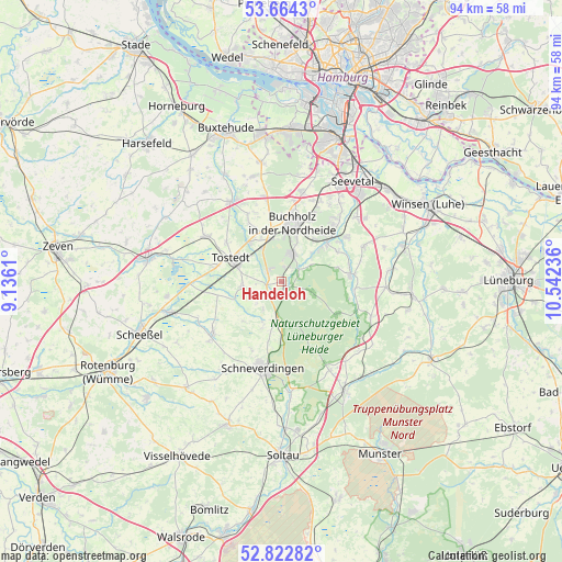
Handeloh GPS coordinates[2]
53° 14' 44.268" North, 9° 50' 21.228" East
| Map corner | latitude | longitude |
|---|---|---|
| Upper-left | 53.6643°, | 9.1361° |
| Center: | 53.24563°, | 9.83923° |
| Lower-right: | 52.82282°, | 10.54236° |
| Map W x H: | 93.6×93.6 km | = 58.2×58.2mi |
| max Lat: | 55.01917° ⇑16.7% North |
| Handeloh: | 53.24563° |
| min Lat: | ⇓83.3% South 47.40724° |
| min Long | Handeloh | max Long |
| 5.92978° | 9.83923° | 14.98853° |
| W 47.7%⇐ | ⇒52.3% E |
Elevation
Elevation of Handeloh is 56 m = 184 ft, and this is 193.1 m = 634 ft below average elevation for this country.
| Max E: |
1256 m = 4121 ft | 77% |
| Avg. | 249.1 m = 817 ft | |
| Handeloh | 56 m = 184 ft | |
Min E: |
-5 m = -16 ft | 23% |
See also: Germany elevation on elevation.city.
Geographical zone
Handeloh is located in North temperate zone (between Tropic of Cancer and the Arctic Circle). Distance of this North polar circle is 1480.8 km =920.1 mi to North.| Distance of | km | miles | from Handeloh |
|---|---|---|---|
| North Pole | 4086.7 | 2539.4 | to North |
| Arctic Circle | 1480.8 | 920.1 | to North |
| Tropic Cancer | 3314.4 | 2059.5 | to South |
| Equator | 5920.4 | 3678.8 | to South |


Nearby cities:
15 places around Handeloh: (largest is in red/bold)
• Asendorf
10.7 km =6.6 mi,  60°
60°
• Bendestorf
12.9 km =8 mi,  39°
39°
• Buchholz in der Nordheide
9.2 km =5.7 mi,  12°
12°
• Dohren
11.1 km =6.9 mi,  303°
303°
• Drestedt
10.9 km =6.8 mi,  330°
330°
• Hanstedt
12 km =7.5 mi,  78°
78°
• Jesteburg
10.4 km =6.5 mi,  46°
46°
• Kakenstorf
8.2 km =5.1 mi,  321°
321°
• Königsmoor
10.8 km =6.7 mi,  258°
258°
• Otter
6.5 km =4 mi, 264°
• Tostedt
9.2 km =5.7 mi, 297°
• Undeloh
10.6 km =6.6 mi,  120°
120°
• Welle
2.6 km =1.6 mi, 255°
• Wenzendorf
12.4 km =7.7 mi,  338°
338°
• Wistedt
10.6 km =6.6 mi,  282°
282°
Sources, notices
• [Note1] Compared only with cities in Germany existing in our database
• [Src1] Map data: © OpenStreetMap contributors (CC-BY-SA)
• [Src2] Other city data from geonames.org with taken over terms of usage.
• [Src3] Geographical zone / Annual Mean Temperature by Robert A. Rohde @ Wikipedia
