Otter geodata
Otter (Lower Saxony) is a seat of a fourth-order administrative division; located in Germany in Europe/Berlin (GMT+2) time zone. With population of 1,443 people, there are 5996 cities with bigger population in this country. Compared to other cities in Germany, 83.2% of cities are located further ↓South; 53.7% of cities are located further →East and 77% of cities have higher elevation than Otter. Note1


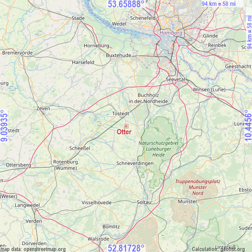
Otter GPS coordinates[2]
53° 14' 24.54" North, 9° 44' 32.892" East
| Map corner | latitude | longitude |
|---|---|---|
| Upper-left | 53.65888°, | 9.03935° |
| Center: | 53.24015°, | 9.74247° |
| Lower-right: | 52.81728°, | 10.4456° |
| Map W x H: | 93.6×93.6 km | = 58.2×58.2mi |
| max Lat: | 55.01917° ⇑16.8% North |
| Otter: | 53.24015° |
| min Lat: | ⇓83.2% South 47.40724° |
| min Long | Otter | max Long |
| 5.92978° | 9.74247° | 14.98853° |
| W 46.3%⇐ | ⇒53.7% E |
Elevation
Elevation of Otter is 56 m = 184 ft, and this is 193.1 m = 634 ft below average elevation for this country.
| Max E: |
1256 m = 4121 ft | 77% |
| Avg. | 249.1 m = 817 ft | |
| Otter | 56 m = 184 ft | |
Min E: |
-5 m = -16 ft | 23% |
See also: Germany elevation on elevation.city.
Geographical zone
Otter is located in North temperate zone (between Tropic of Cancer and the Arctic Circle). Distance of this North polar circle is 1481.4 km =920.5 mi to North.| Distance of | km | miles | from Otter |
|---|---|---|---|
| North Pole | 4087.3 | 2539.7 | to North |
| Arctic Circle | 1481.4 | 920.5 | to North |
| Tropic Cancer | 3313.8 | 2059.1 | to South |
| Equator | 5919.7 | 3678.3 | to South |


Nearby cities:
15 places around Otter: (largest is in red/bold)
• Buchholz in der Nordheide
12.7 km =7.9 mi,  41°
41°
• Dohren
7.2 km =4.5 mi,  337°
337°
• Drestedt
10.1 km =6.3 mi,  5°
5°
• Fintel
9 km =5.6 mi,  212°
212°
• Handeloh
6.5 km =4 mi,  84°
84°
• Heidenau
9.9 km =6.2 mi,  329°
329°
• Kakenstorf
7.1 km =4.4 mi, 10°
• Königsmoor
4.5 km =2.8 mi,  249°
249°
• Lauenbrück
12.5 km =7.8 mi, 249°
• Stemmen
12.7 km =7.9 mi,  262°
262°
• Tostedt
5.1 km =3.2 mi, 340°
• Vahlde
9.6 km =6 mi,  230°
230°
• Welle
3.9 km =2.4 mi,  90°
90°
• Wenzendorf
12.3 km =7.6 mi, 9°
• Wistedt
4.9 km =3 mi,  306°
306°
Sources, notices
• [Note1] Compared only with cities in Germany existing in our database
• [Src1] Map data: © OpenStreetMap contributors (CC-BY-SA)
• [Src2] Other city data from geonames.org with taken over terms of usage.
• [Src3] Geographical zone / Annual Mean Temperature by Robert A. Rohde @ Wikipedia
