Tostedt geodata
Tostedt (Lower Saxony) is a seat of a fourth-order administrative division; located in Germany in Europe/Berlin (GMT+2) time zone. With population of 13,315 people, there are 1201 cities with bigger population in this country. Compared to other cities in Germany, 83.5% of cities are located further ↓South; 54.2% of cities are located further →East and 75.3% of cities have higher elevation than Tostedt. Note1


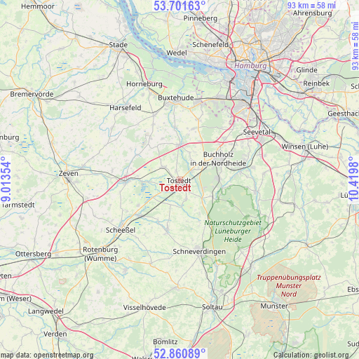
Tostedt GPS coordinates[2]
53° 16' 59.988" North, 9° 43' 0.012" East
| Map corner | latitude | longitude |
|---|---|---|
| Upper-left | 53.70163°, | 9.01354° |
| Center: | 53.28333°, | 9.71667° |
| Lower-right: | 52.86089°, | 10.4198° |
| Map W x H: | 93.5×93.5 km | = 58.1×58.1mi |
| max Lat: | 55.01917° ⇑16.5% North |
| Tostedt: | 53.28333° |
| min Lat: | ⇓83.5% South 47.40724° |
| min Long | Tostedt | max Long |
| 5.92978° | 9.71667° | 14.98853° |
| W 45.8%⇐ | ⇒54.2% E |
Elevation
Elevation of Tostedt is 62 m = 203 ft, and this is 187.1 m = 614 ft below average elevation for this country.
| Max E: |
1256 m = 4121 ft | 75.3% |
| Avg. | 249.1 m = 817 ft | |
| Tostedt | 62 m = 203 ft | |
Min E: |
-5 m = -16 ft | 24.7% |
See also: Germany elevation on elevation.city.
Geographical zone
Tostedt is located in North temperate zone (between Tropic of Cancer and the Arctic Circle). Distance of this North polar circle is 1476.6 km =917.5 mi to North.| Distance of | km | miles | from Tostedt |
|---|---|---|---|
| North Pole | 4082.5 | 2536.7 | to North |
| Arctic Circle | 1476.6 | 917.5 | to North |
| Tropic Cancer | 3318.6 | 2062.1 | to South |
| Equator | 5924.6 | 3681.4 | to South |


Nearby cities:
15 places around Tostedt: (largest is in red/bold)
• Buchholz in der Nordheide
11.1 km =6.9 mi,  64°
64°
• Dohren
2.2 km =1.4 mi,  329°
329°
• Drestedt
5.9 km =3.7 mi,  27°
27°
• Halvesbostel
11.2 km =7 mi,  315°
315°
• Handeloh
9.2 km =5.7 mi,  117°
117°
• Heidenau
5 km =3.1 mi, 318°
• Hollenstedt
9.3 km =5.8 mi,  0°
0°
• Kakenstorf
3.8 km =2.4 mi,  54°
54°
• Kalbe
11.1 km =6.9 mi,  275°
275°
• Königsmoor
6.8 km =4.2 mi,  201°
201°
• Otter
5.1 km =3.2 mi,  160°
160°
• Regesbostel
12 km =7.5 mi,  338°
338°
• Welle
7.4 km =4.6 mi,  130°
130°
• Wenzendorf
8.2 km =5.1 mi, 26°
• Wistedt
2.9 km =1.8 mi,  230°
230°
Sources, notices
• [Note1] Compared only with cities in Germany existing in our database
• [Src1] Map data: © OpenStreetMap contributors (CC-BY-SA)
• [Src2] Other city data from geonames.org with taken over terms of usage.
• [Src3] Geographical zone / Annual Mean Temperature by Robert A. Rohde @ Wikipedia
