Hakenfelde geodata
Hakenfelde (Berlin) is a section of populated place; located in Germany in Europe/Berlin (GMT+2) time zone. With population of 26,940 people, there are 538 cities with bigger population in this country. Compared to other cities in Germany, 78.2% of cities are located further ↓South; 93.7% of cities are located further ←West and 84.1% of cities have higher elevation than Hakenfelde. Note1


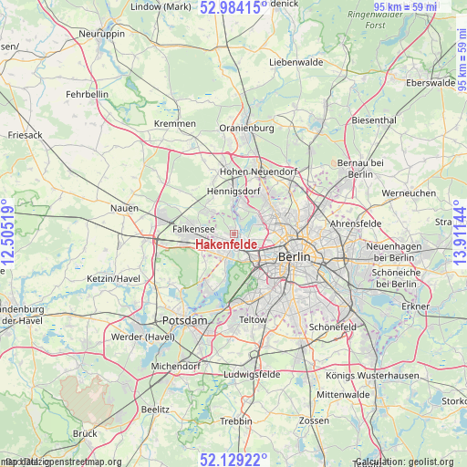
Hakenfelde GPS coordinates[2]
52° 33' 31.572" North, 13° 12' 29.916" East
| Map corner | latitude | longitude |
|---|---|---|
| Upper-left | 52.98415°, | 12.50519° |
| Center: | 52.55877°, | 13.20831° |
| Lower-right: | 52.12922°, | 13.91144° |
| Map W x H: | 95.1×95.1 km | = 59.1×59.1mi |
| max Lat: | 55.01917° ⇑21.8% North |
| Hakenfelde: | 52.55877° |
| min Lat: | ⇓78.2% South 47.40724° |
| min Long | Hakenfelde | max Long |
| 5.92978° | 13.20831° | 14.98853° |
| W 93.7%⇐ | ⇒6.3% E |
Elevation
Elevation of Hakenfelde is 37 m = 121 ft, and this is 212.1 m = 696 ft below average elevation for this country.
| Max E: |
1256 m = 4121 ft | 84.1% |
| Avg. | 249.1 m = 817 ft | |
| Hakenfelde | 37 m = 121 ft | |
Min E: |
-5 m = -16 ft | 15.9% |
See also: Germany elevation on elevation.city.
Geographical zone
Hakenfelde is located in North temperate zone (between Tropic of Cancer and the Arctic Circle). Distance of this North polar circle is 1557.2 km =967.6 mi to North.| Distance of | km | miles | from Hakenfelde |
|---|---|---|---|
| North Pole | 4163.1 | 2586.8 | to North |
| Arctic Circle | 1557.2 | 967.6 | to North |
| Tropic Cancer | 3238.1 | 2012.1 | to South |
| Equator | 5844 | 3631.3 | to South |


Nearby cities:
15 places around Hakenfelde: (largest is in red/bold)
• Charlottenburg
6.9 km =4.3 mi,  132°
132°
• Charlottenburg-Nord
6.6 km =4.1 mi,  118°
118°
• Falkenhagener Feld
2.8 km =1.7 mi,  254°
254°
• Falkensee
7.8 km =4.8 mi,  271°
271°
• Haselhorst
2.6 km =1.6 mi, 129°
• Heiligensee
6.7 km =4.2 mi,  21°
21°
• Konradshöhe
3.2 km =2 mi, 23°
• Reinickendorf
8.5 km =5.3 mi,  84°
84°
• Siemensstadt
4.2 km =2.6 mi, 118°
• Spandau
1.1 km =0.7 mi,  215°
215°
• Staaken
4.6 km =2.9 mi,  237°
237°
• Tegel
6.1 km =3.8 mi,  71°
71°
• Westend
6.5 km =4 mi,  135°
135°
• Wilhelmstadt
4.3 km =2.7 mi,  209°
209°
• Wittenau
8.5 km =5.3 mi,  63°
63°
Sources, notices
• [Note1] Compared only with cities in Germany existing in our database
• [Src1] Map data: © OpenStreetMap contributors (CC-BY-SA)
• [Src2] Other city data from geonames.org with taken over terms of usage.
• [Src3] Geographical zone / Annual Mean Temperature by Robert A. Rohde @ Wikipedia
