Charlottenburg-Nord geodata
Charlottenburg-Nord (Berlin) is a section of populated place; located in Germany in Europe/Berlin (GMT+2) time zone. With population of 17,942 people, there are 879 cities with bigger population in this country. Compared to other cities in Germany, 77.8% of cities are located further ↓South; 94.3% of cities are located further ←West and 87.7% of cities have higher elevation than Charlottenburg-Nord. Note1


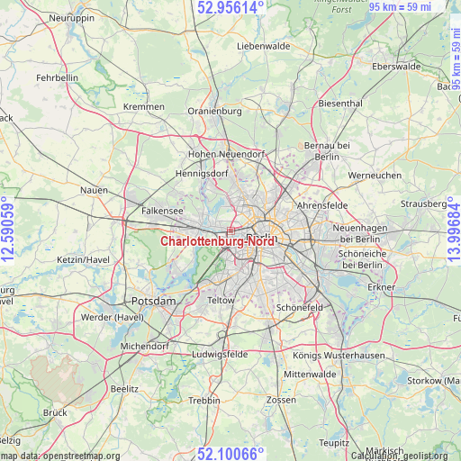
Charlottenburg-Nord GPS coordinates[2]
52° 31' 49.728" North, 13° 17' 37.356" East
| Map corner | latitude | longitude |
|---|---|---|
| Upper-left | 52.95614°, | 12.59059° |
| Center: | 52.53048°, | 13.29371° |
| Lower-right: | 52.10066°, | 13.99684° |
| Map W x H: | 95.1×95.1 km | = 59.1×59.1mi |
| max Lat: | 55.01917° ⇑22.2% North |
| Charlottenburg-Nord: | 52.53048° |
| min Lat: | ⇓77.8% South 47.40724° |
| min Long | Charlottenburg- | max Long |
| 5.92978° | 13.29371° | 14.98853° |
| W 94.3%⇐ | ⇒5.7% E |
Elevation
Elevation of Charlottenburg-Nord is 28 m = 92 ft, and this is 221.1 m = 725 ft below average elevation for this country.
| Max E: |
1256 m = 4121 ft | 87.7% |
| Avg. | 249.1 m = 817 ft | |
| Charlottenburg-Nord | 28 m = 92 ft | |
Min E: |
-5 m = -16 ft | 12.3% |
See also: Germany elevation on elevation.city.
Geographical zone
Charlottenburg-Nord is located in North temperate zone (between Tropic of Cancer and the Arctic Circle). Distance of this North polar circle is 1560.3 km =969.5 mi to North.| Distance of | km | miles | from Charlottenburg-Nord |
|---|---|---|---|
| North Pole | 4166.2 | 2588.8 | to North |
| Arctic Circle | 1560.3 | 969.5 | to North |
| Tropic Cancer | 3234.9 | 2010.1 | to South |
| Equator | 5840.8 | 3629.3 | to South |


Nearby cities:
15 places around Charlottenburg-Nord: (largest is in red/bold)
• Charlottenburg
1.7 km =1.1 mi,  204°
204°
• Grunewald
5.6 km =3.5 mi, 199°
• Hakenfelde
6.6 km =4.1 mi,  298°
298°
• Halensee
4.5 km =2.8 mi,  178°
178°
• Hansaviertel
3.5 km =2.2 mi,  112°
112°
• Haselhorst
4.1 km =2.5 mi,  291°
291°
• Moabit
3.1 km =1.9 mi,  98°
98°
• Reinickendorf
4.8 km =3 mi,  33°
33°
• Schmargendorf
6.2 km =3.9 mi, 181°
• Siemensstadt
2.4 km =1.5 mi, 298°
• Tegel
5.1 km =3.2 mi,  0°
0°
• Tiergarten
5.2 km =3.2 mi, 107°
• Wedding
4.6 km =2.9 mi,  65°
65°
• Westend
1.9 km =1.2 mi,  218°
218°
• Wilmersdorf
5.5 km =3.4 mi,  163°
163°
Sources, notices
• [Note1] Compared only with cities in Germany existing in our database
• [Src1] Map data: © OpenStreetMap contributors (CC-BY-SA)
• [Src2] Other city data from geonames.org with taken over terms of usage.
• [Src3] Geographical zone / Annual Mean Temperature by Robert A. Rohde @ Wikipedia
