Konradshöhe geodata
Konradshöhe (Berlin) is a section of populated place; located in Germany in Europe/Berlin (GMT+2) time zone. With population of 5,939 people, there are 2482 cities with bigger population in this country. Compared to other cities in Germany, 78.6% of cities are located further ↓South; 93.8% of cities are located further ←West and 83.2% of cities have higher elevation than Konradshöhe. Note1


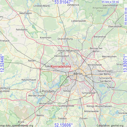
Konradshöhe GPS coordinates[2]
52° 35' 7.26" North, 13° 13' 39.288" East
| Map corner | latitude | longitude |
|---|---|---|
| Upper-left | 53.01047°, | 12.52446° |
| Center: | 52.58535°, | 13.22758° |
| Lower-right: | 52.15606°, | 13.93071° |
| Map W x H: | 95×95 km | = 59×59mi |
| max Lat: | 55.01917° ⇑21.4% North |
| Konradshöhe: | 52.58535° |
| min Lat: | ⇓78.6% South 47.40724° |
| min Long | Konradshöhe | max Long |
| 5.92978° | 13.22758° | 14.98853° |
| W 93.8%⇐ | ⇒6.2% E |
Elevation
Elevation of Konradshöhe is 39 m = 128 ft, and this is 210.1 m = 689 ft below average elevation for this country.
| Max E: |
1256 m = 4121 ft | 83.2% |
| Avg. | 249.1 m = 817 ft | |
| Konradshöhe | 39 m = 128 ft | |
Min E: |
-5 m = -16 ft | 16.8% |
See also: Germany elevation on elevation.city.
Geographical zone
Konradshöhe is located in North temperate zone (between Tropic of Cancer and the Arctic Circle). Distance of this North polar circle is 1554.2 km =965.7 mi to North.| Distance of | km | miles | from Konradshöhe |
|---|---|---|---|
| North Pole | 4160.1 | 2585 | to North |
| Arctic Circle | 1554.2 | 965.7 | to North |
| Tropic Cancer | 3241 | 2013.9 | to South |
| Equator | 5846.9 | 3633.1 | to South |


Nearby cities:
15 places around Konradshöhe: (largest is in red/bold)
• Charlottenburg-Nord
7.6 km =4.7 mi,  143°
143°
• Falkenhagener Feld
5.5 km =3.4 mi,  227°
227°
• Frohnau
6.8 km =4.2 mi,  38°
38°
• Hakenfelde
3.2 km =2 mi,  203°
203°
• Haselhorst
4.6 km =2.9 mi,  171°
171°
• Heiligensee
3.4 km =2.1 mi,  19°
19°
• Hennigsdorf
5.8 km =3.6 mi,  344°
344°
• Hermsdorf
6.2 km =3.9 mi,  58°
58°
• Reinickendorf
7.4 km =4.6 mi,  106°
106°
• Siemensstadt
5.5 km =3.4 mi,  154°
154°
• Spandau
4.3 km =2.7 mi,  206°
206°
• Staaken
7.5 km =4.7 mi,  223°
223°
• Tegel
4.6 km =2.9 mi,  103°
103°
• Waidmannslust
6.7 km =4.2 mi,  68°
68°
• Wittenau
6.4 km =4 mi,  82°
82°
Sources, notices
• [Note1] Compared only with cities in Germany existing in our database
• [Src1] Map data: © OpenStreetMap contributors (CC-BY-SA)
• [Src2] Other city data from geonames.org with taken over terms of usage.
• [Src3] Geographical zone / Annual Mean Temperature by Robert A. Rohde @ Wikipedia
