Haselhorst geodata
Haselhorst (Berlin) is a section of populated place; located in Germany in Europe/Berlin (GMT+2) time zone. With population of 13,624 people, there are 1175 cities with bigger population in this country. Compared to other cities in Germany, 78% of cities are located further ↓South; 93.9% of cities are located further ←West and 85.4% of cities have higher elevation than Haselhorst. Note1


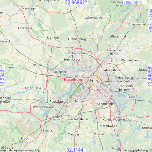
Haselhorst GPS coordinates[2]
52° 32' 38.724" North, 13° 14' 14.748" East
| Map corner | latitude | longitude |
|---|---|---|
| Upper-left | 52.96962°, | 12.53431° |
| Center: | 52.54409°, | 13.23743° |
| Lower-right: | 52.1144°, | 13.94056° |
| Map W x H: | 95.1×95.1 km | = 59.1×59.1mi |
| max Lat: | 55.01917° ⇑22% North |
| Haselhorst: | 52.54409° |
| min Lat: | ⇓78% South 47.40724° |
| min Long | Haselhorst | max Long |
| 5.92978° | 13.23743° | 14.98853° |
| W 93.9%⇐ | ⇒6.1% E |
Elevation
Elevation of Haselhorst is 34 m = 112 ft, and this is 215.1 m = 706 ft below average elevation for this country.
| Max E: |
1256 m = 4121 ft | 85.4% |
| Avg. | 249.1 m = 817 ft | |
| Haselhorst | 34 m = 112 ft | |
Min E: |
-5 m = -16 ft | 14.6% |
See also: Germany elevation on elevation.city.
Geographical zone
Haselhorst is located in North temperate zone (between Tropic of Cancer and the Arctic Circle). Distance of this North polar circle is 1558.8 km =968.6 mi to North.| Distance of | km | miles | from Haselhorst |
|---|---|---|---|
| North Pole | 4164.7 | 2587.8 | to North |
| Arctic Circle | 1558.8 | 968.6 | to North |
| Tropic Cancer | 3236.4 | 2011 | to South |
| Equator | 5842.4 | 3630.3 | to South |


Nearby cities:
15 places around Haselhorst: (largest is in red/bold)
• Charlottenburg
4.4 km =2.7 mi,  134°
134°
• Charlottenburg-Nord
4.1 km =2.5 mi,  111°
111°
• Falkenhagener Feld
4.8 km =3 mi,  280°
280°
• Grunewald
7 km =4.3 mi,  164°
164°
• Hakenfelde
2.6 km =1.6 mi,  309°
309°
• Halensee
7.2 km =4.5 mi,  146°
146°
• Konradshöhe
4.6 km =2.9 mi,  351°
351°
• Moabit
7.1 km =4.4 mi, 106°
• Reinickendorf
7 km =4.3 mi,  68°
68°
• Siemensstadt
1.8 km =1.1 mi,  102°
102°
• Spandau
2.7 km =1.7 mi,  286°
286°
• Staaken
5.9 km =3.7 mi,  261°
261°
• Tegel
5.2 km =3.2 mi,  47°
47°
• Westend
4 km =2.5 mi,  138°
138°
• Wilhelmstadt
4.6 km =2.9 mi,  242°
242°
Sources, notices
• [Note1] Compared only with cities in Germany existing in our database
• [Src1] Map data: © OpenStreetMap contributors (CC-BY-SA)
• [Src2] Other city data from geonames.org with taken over terms of usage.
• [Src3] Geographical zone / Annual Mean Temperature by Robert A. Rohde @ Wikipedia
