Siemensstadt geodata
Siemensstadt (Berlin) is a section of populated place; located in Germany in Europe/Berlin (GMT+2) time zone. With population of 11,899 people, there are 1378 cities with bigger population in this country. Compared to other cities in Germany, 77.9% of cities are located further ↓South; 94.1% of cities are located further ←West and 85.4% of cities have higher elevation than Siemensstadt. Note1


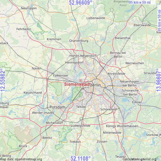
Siemensstadt GPS coordinates[2]
52° 32' 25.908" North, 13° 15' 46.584" East
| Map corner | latitude | longitude |
|---|---|---|
| Upper-left | 52.96609°, | 12.55982° |
| Center: | 52.54053°, | 13.26294° |
| Lower-right: | 52.1108°, | 13.96607° |
| Map W x H: | 95.1×95.1 km | = 59.1×59.1mi |
| max Lat: | 55.01917° ⇑22.1% North |
| Siemensstadt: | 52.54053° |
| min Lat: | ⇓77.9% South 47.40724° |
| min Long | Siemensstadt | max Long |
| 5.92978° | 13.26294° | 14.98853° |
| W 94.1%⇐ | ⇒5.9% E |
Elevation
Elevation of Siemensstadt is 34 m = 112 ft, and this is 215.1 m = 706 ft below average elevation for this country.
| Max E: |
1256 m = 4121 ft | 85.4% |
| Avg. | 249.1 m = 817 ft | |
| Siemensstadt | 34 m = 112 ft | |
Min E: |
-5 m = -16 ft | 14.6% |
See also: Germany elevation on elevation.city.
Geographical zone
Siemensstadt is located in North temperate zone (between Tropic of Cancer and the Arctic Circle). Distance of this North polar circle is 1559.2 km =968.8 mi to North.| Distance of | km | miles | from Siemensstadt |
|---|---|---|---|
| North Pole | 4165.1 | 2588.1 | to North |
| Arctic Circle | 1559.2 | 968.8 | to North |
| Tropic Cancer | 3236 | 2010.8 | to South |
| Equator | 5842 | 3630 | to South |


Nearby cities:
15 places around Siemensstadt: (largest is in red/bold)
• Charlottenburg
3 km =1.9 mi,  152°
152°
• Charlottenburg-Nord
2.4 km =1.5 mi,  118°
118°
• Grunewald
6.4 km =4 mi,  178°
178°
• Hakenfelde
4.2 km =2.6 mi,  298°
298°
• Halensee
6 km =3.7 mi,  158°
158°
• Hansaviertel
5.9 km =3.7 mi,  114°
114°
• Haselhorst
1.8 km =1.1 mi,  282°
282°
• Konradshöhe
5.5 km =3.4 mi,  334°
334°
• Moabit
5.4 km =3.4 mi, 107°
• Reinickendorf
5.6 km =3.5 mi,  58°
58°
• Spandau
4.5 km =2.8 mi,  285°
285°
• Tegel
4.5 km =2.8 mi,  27°
27°
• Wedding
6.3 km =3.9 mi,  83°
83°
• Westend
2.8 km =1.7 mi, 160°
• Wilhelmstadt
6.1 km =3.8 mi,  253°
253°
Sources, notices
• [Note1] Compared only with cities in Germany existing in our database
• [Src1] Map data: © OpenStreetMap contributors (CC-BY-SA)
• [Src2] Other city data from geonames.org with taken over terms of usage.
• [Src3] Geographical zone / Annual Mean Temperature by Robert A. Rohde @ Wikipedia
