Haidemühl geodata
Haidemühl (Brandenburg) is a populated place; located in Germany in Europe/Berlin (GMT+2) time zone. With population of 571 people, there are 8967 cities with bigger population in this country. Compared to other cities in Germany, 66.9% of cities are located further ↓South; 98.7% of cities are located further ←West and 65.7% of cities have higher elevation than Haidemühl. Note1


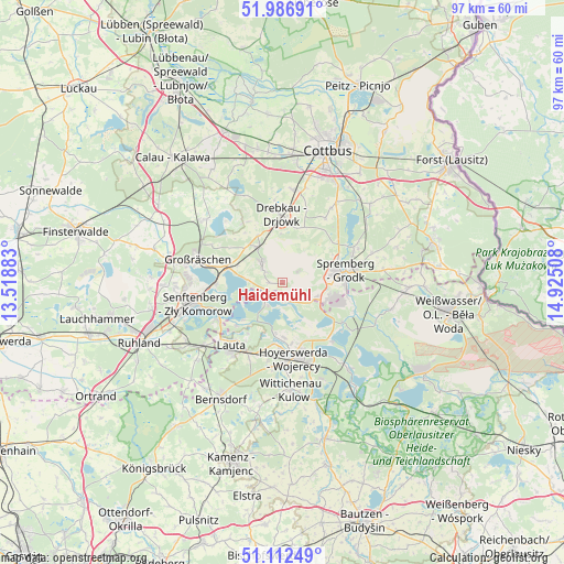
Haidemühl GPS coordinates[2]
51° 33' 6.48" North, 14° 13' 19.02" East
| Map corner | latitude | longitude |
|---|---|---|
| Upper-left | 51.98691°, | 13.51883° |
| Center: | 51.5518°, | 14.22195° |
| Lower-right: | 51.11249°, | 14.92508° |
| Map W x H: | 97.2×97.2 km | = 60.4×60.4mi |
| max Lat: | 55.01917° ⇑33.1% North |
| Haidemühl: | 51.5518° |
| min Lat: | ⇓66.9% South 47.40724° |
| min Long | Haidemühl | max Long |
| 5.92978° | 14.22195° | 14.98853° |
| W 98.7%⇐ | ⇒1.3% E |
Elevation
Elevation of Haidemühl is 116 m = 381 ft, and this is 133.1 m = 437 ft below average elevation for this country.
| Max E: |
1256 m = 4121 ft | 65.7% |
| Avg. | 249.1 m = 817 ft | |
| Haidemühl | 116 m = 381 ft | |
Min E: |
-5 m = -16 ft | 34.3% |
See also: Germany elevation on elevation.city.
Geographical zone
Haidemühl is located in North temperate zone (between Tropic of Cancer and the Arctic Circle). Distance of this North polar circle is 1669.2 km =1037.2 mi to North.| Distance of | km | miles | from Haidemühl |
|---|---|---|---|
| North Pole | 4275 | 2656.4 | to North |
| Arctic Circle | 1669.2 | 1037.2 | to North |
| Tropic Cancer | 3126.1 | 1942.5 | to South |
| Equator | 5732 | 3561.7 | to South |


Nearby cities:
15 places around Haidemühl: (largest is in red/bold)
• Altdöbern
17 km =10.6 mi,  309°
309°
• Drebkau
11.4 km =7.1 mi,  0°
0°
• Groß Döbbern
13.4 km =8.3 mi,  33°
33°
• Groß Oßnig
17 km =10.6 mi, 33°
• Großräschen
15.1 km =9.4 mi,  285°
285°
• Hohenbocka
19.9 km =12.4 mi,  227°
227°
• Hoyerswerda
12.7 km =7.9 mi,  175°
175°
• Knappenrode
17.9 km =11.1 mi,  157°
157°
• Laubsdorf
20.4 km =12.7 mi,  48°
48°
• Neupetershain
7.4 km =4.6 mi,  327°
327°
• Schleife
21.6 km =13.4 mi,  95°
95°
• Senftenberg
15.5 km =9.6 mi,  259°
259°
• Spremberg
10.7 km =6.6 mi,  79°
79°
• Welzow
5 km =3.1 mi,  315°
315°
• Wittichenau
18.6 km =11.6 mi, 175°
Sources, notices
• [Note1] Compared only with cities in Germany existing in our database
• [Src1] Map data: © OpenStreetMap contributors (CC-BY-SA)
• [Src2] Other city data from geonames.org with taken over terms of usage.
• [Src3] Geographical zone / Annual Mean Temperature by Robert A. Rohde @ Wikipedia
