Senftenberg geodata
Senftenberg (Brandenburg) is a seat of a third-order administrative division; located in Germany in Europe/Berlin (GMT+2) time zone. With population of 28,988 people, there are 487 cities with bigger population in this country. Compared to other cities in Germany, 66.6% of cities are located further ↓South; 97.9% of cities are located further ←West and 67.6% of cities have higher elevation than Senftenberg. Note1
Administrative division(s):
- Level 1: Brandenburg
- Level 3: Landkreis Oberspreewald-Lausitz
- Level 4: Senftenberg


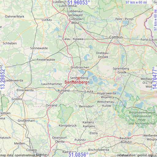
Senftenberg GPS coordinates[2]
51° 31' 30.612" North, 14° 0' 5.904" East
| Map corner | latitude | longitude |
|---|---|---|
| Upper-left | 51.96053°, | 13.29852° |
| Center: | 51.52517°, | 14.00164° |
| Lower-right: | 51.0856°, | 14.70477° |
| Map W x H: | 97.3×97.3 km | = 60.5×60.5mi |
| max Lat: | 55.01917° ⇑33.4% North |
| Senftenberg: | 51.52517° |
| min Lat: | ⇓66.6% South 47.40724° |
| min Long | Senftenberg | max Long |
| 5.92978° | 14.00164° | 14.98853° |
| W 97.9%⇐ | ⇒2.1% E |
Elevation
Elevation of Senftenberg is 104 m = 341 ft, and this is 145.1 m = 476 ft below average elevation for this country.
| Max E: |
1256 m = 4121 ft | 67.6% |
| Avg. | 249.1 m = 817 ft | |
| Senftenberg | 104 m = 341 ft | |
Min E: |
-5 m = -16 ft | 32.4% |
See also: Germany elevation on elevation.city.
Geographical zone
Senftenberg is located in North temperate zone (between Tropic of Cancer and the Arctic Circle). Distance of this North polar circle is 1672.1 km =1039 mi to North.| Distance of | km | miles | from Senftenberg |
|---|---|---|---|
| North Pole | 4278 | 2658.2 | to North |
| Arctic Circle | 1672.1 | 1039 | to North |
| Tropic Cancer | 3123.1 | 1940.6 | to South |
| Equator | 5729.1 | 3559.9 | to South |


Nearby cities:
15 places around Senftenberg: (largest is in red/bold)
• Altdöbern
14.1 km =8.8 mi,  8°
8°
• Großräschen
7 km =4.3 mi, 5°
• Grünewald
13.9 km =8.6 mi,  180°
180°
• Guteborn
13 km =8.1 mi,  201°
201°
• Haidemühl
15.5 km =9.6 mi,  79°
79°
• Hermsdorf
15.3 km =9.5 mi,  209°
209°
• Hohenbocka
10.5 km =6.5 mi, 176°
• Neupetershain
14.6 km =9.1 mi,  50°
50°
• Ruhland
12 km =7.5 mi,  231°
231°
• Sallgast
12.7 km =7.9 mi,  303°
303°
• Schipkau
7.3 km =4.5 mi,  263°
263°
• Schwarzbach
9.6 km =6 mi, 209°
• Schwarzheide
11.5 km =7.1 mi,  241°
241°
• Welzow
13.4 km =8.3 mi,  60°
60°
• Wiednitz
15.6 km =9.7 mi,  173°
173°
Sources, notices
• [Note1] Compared only with cities in Germany existing in our database
• [Src1] Map data: © OpenStreetMap contributors (CC-BY-SA)
• [Src2] Other city data from geonames.org with taken over terms of usage.
• [Src3] Geographical zone / Annual Mean Temperature by Robert A. Rohde @ Wikipedia
