Hoyerswerda geodata
Hoyerswerda (Saxony) is a populated place; located in Germany in Europe/Berlin (GMT+2) time zone. With population of 43,681 people, there are 276 cities with bigger population in this country. Compared to other cities in Germany, 65.4% of cities are located further ↓South; 98.7% of cities are located further ←West and 65.4% of cities have higher elevation than Hoyerswerda. Note1


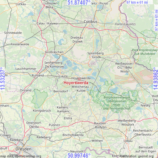
Hoyerswerda GPS coordinates[2]
51° 26' 16.332" North, 14° 14' 7.764" East
| Map corner | latitude | longitude |
|---|---|---|
| Upper-left | 51.87407°, | 13.53237° |
| Center: | 51.43787°, | 14.23549° |
| Lower-right: | 50.99746°, | 14.93862° |
| Map W x H: | 97.5×97.5 km | = 60.6×60.6mi |
| max Lat: | 55.01917° ⇑34.6% North |
| Hoyerswerda: | 51.43787° |
| min Lat: | ⇓65.4% South 47.40724° |
| min Long | Hoyerswerda | max Long |
| 5.92978° | 14.23549° | 14.98853° |
| W 98.7%⇐ | ⇒1.3% E |
Elevation
Elevation of Hoyerswerda is 118 m = 387 ft, and this is 131.1 m = 430 ft below average elevation for this country.
| Max E: |
1256 m = 4121 ft | 65.4% |
| Avg. | 249.1 m = 817 ft | |
| Hoyerswerda | 118 m = 387 ft | |
Min E: |
-5 m = -16 ft | 34.6% |
See also: Hoyerswerda elevation on elevation.city.
Geographical zone
Hoyerswerda is located in North temperate zone (between Tropic of Cancer and the Arctic Circle). Distance of this North polar circle is 1681.8 km =1045 mi to North.| Distance of | km | miles | from Hoyerswerda |
|---|---|---|---|
| North Pole | 4287.7 | 2664.3 | to North |
| Arctic Circle | 1681.8 | 1045 | to North |
| Tropic Cancer | 3113.4 | 1934.6 | to South |
| Equator | 5719.4 | 3553.9 | to South |


Nearby cities:
15 places around Hoyerswerda: (largest is in red/bold)
• Bernsdorf
13.6 km =8.5 mi,  238°
238°
• Grünewald
16.9 km =10.5 mi,  255°
255°
• Haidemühl
12.7 km =7.9 mi,  355°
355°
• Hohenbocka
15.7 km =9.8 mi,  267°
267°
• Horka
19.4 km =12.1 mi,  175°
175°
• Knappenrode
7 km =4.3 mi,  123°
123°
• Königswartha
15.6 km =9.7 mi,  155°
155°
• Lohsa
12.9 km =8 mi, 117°
• Oßling
9.9 km =6.2 mi,  209°
209°
• Senftenberg
18.9 km =11.7 mi,  300°
300°
• Spremberg
17.5 km =10.9 mi,  33°
33°
• Straßgräbchen
15.2 km =9.4 mi,  231°
231°
• Welzow
16.8 km =10.4 mi,  344°
344°
• Wiednitz
15.6 km =9.7 mi,  248°
248°
• Wittichenau
5.9 km =3.7 mi,  174°
174°
Sources, notices
• [Note1] Compared only with cities in Germany existing in our database
• [Src1] Map data: © OpenStreetMap contributors (CC-BY-SA)
• [Src2] Other city data from geonames.org with taken over terms of usage.
• [Src3] Geographical zone / Annual Mean Temperature by Robert A. Rohde @ Wikipedia
