Neupetershain geodata
Neupetershain (Brandenburg) is a seat of a fourth-order administrative division; located in Germany in Europe/Berlin (GMT+2) time zone. In our database, there are 11009 cities with bigger population. Compared to other cities in Germany, 67.7% of cities are located further ↓South; 98.5% of cities are located further ←West and 63.6% of cities have higher elevation than Neupetershain. Note1
Administrative division(s):
- Level 1: Brandenburg
- Level 3: Landkreis Oberspreewald-Lausitz
- Level 4: Neupetershain


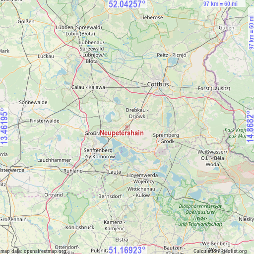
Neupetershain GPS coordinates[2]
51° 36' 28.8" North, 14° 9' 54.252" East
| Map corner | latitude | longitude |
|---|---|---|
| Upper-left | 52.04257°, | 13.46195° |
| Center: | 51.608°, | 14.16507° |
| Lower-right: | 51.16923°, | 14.8682° |
| Map W x H: | 97.1×97.1 km | = 60.3×60.3mi |
| max Lat: | 55.01917° ⇑32.3% North |
| Neupetershain: | 51.608° |
| min Lat: | ⇓67.7% South 47.40724° |
| min Long | Neupetershain | max Long |
| 5.92978° | 14.16507° | 14.98853° |
| W 98.5%⇐ | ⇒1.5% E |
Elevation
Elevation of Neupetershain is 128 m = 420 ft, and this is 121.1 m = 397 ft below average elevation for this country.
| Max E: |
1256 m = 4121 ft | 63.6% |
| Avg. | 249.1 m = 817 ft | |
| Neupetershain | 128 m = 420 ft | |
Min E: |
-5 m = -16 ft | 36.4% |
See also: Germany elevation on elevation.city.
Geographical zone
Neupetershain is located in North temperate zone (between Tropic of Cancer and the Arctic Circle). Distance of this North polar circle is 1662.9 km =1033.3 mi to North.| Distance of | km | miles | from Neupetershain |
|---|---|---|---|
| North Pole | 4268.8 | 2652.5 | to North |
| Arctic Circle | 1662.9 | 1033.3 | to North |
| Tropic Cancer | 3132.4 | 1946.4 | to South |
| Equator | 5738.3 | 3565.6 | to South |


Nearby cities:
15 places around Neupetershain: (largest is in red/bold)
• Altdöbern
10.2 km =6.3 mi,  297°
297°
• Bronkow
18.3 km =11.4 mi,  290°
290°
• Cottbus
20.1 km =12.5 mi,  34°
34°
• Drebkau
6.5 km =4 mi,  38°
38°
• Groß Döbbern
12.4 km =7.7 mi,  66°
66°
• Groß Oßnig
15.5 km =9.6 mi,  59°
59°
• Großräschen
10.9 km =6.8 mi,  257°
257°
• Haidemühl
7.4 km =4.6 mi,  147°
147°
• Hoyerswerda
19.5 km =12.1 mi,  165°
165°
• Kolkwitz
16.8 km =10.4 mi,  20°
20°
• Laubsdorf
20.5 km =12.7 mi, 68°
• Senftenberg
14.6 km =9.1 mi,  230°
230°
• Spremberg
15 km =9.3 mi,  106°
106°
• Vetschau
20.7 km =12.9 mi,  343°
343°
• Welzow
2.7 km =1.7 mi, 171°
Sources, notices
• [Note1] Compared only with cities in Germany existing in our database
• [Src1] Map data: © OpenStreetMap contributors (CC-BY-SA)
• [Src2] Other city data from geonames.org with taken over terms of usage.
• [Src3] Geographical zone / Annual Mean Temperature by Robert A. Rohde @ Wikipedia
