Welzow geodata
Welzow (Brandenburg) is a populated place; located in Germany in Europe/Berlin (GMT+2) time zone. With population of 4,240 people, there are 3161 cities with bigger population in this country. Compared to other cities in Germany, 67.4% of cities are located further ↓South; 98.6% of cities are located further ←West and 64.2% of cities have higher elevation than Welzow. Note1


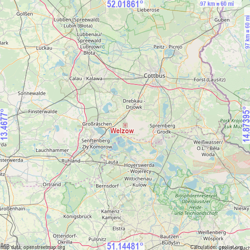
Welzow GPS coordinates[2]
51° 35' 1.716" North, 14° 10' 14.952" East
| Map corner | latitude | longitude |
|---|---|---|
| Upper-left | 52.01861°, | 13.4677° |
| Center: | 51.58381°, | 14.17082° |
| Lower-right: | 51.14481°, | 14.87395° |
| Map W x H: | 97.2×97.2 km | = 60.4×60.4mi |
| max Lat: | 55.01917° ⇑32.6% North |
| Welzow: | 51.58381° |
| min Lat: | ⇓67.4% South 47.40724° |
| min Long | Welzow | max Long |
| 5.92978° | 14.17082° | 14.98853° |
| W 98.6%⇐ | ⇒1.4% E |
Elevation
Elevation of Welzow is 125 m = 410 ft, and this is 124.1 m = 407 ft below average elevation for this country.
| Max E: |
1256 m = 4121 ft | 64.2% |
| Avg. | 249.1 m = 817 ft | |
| Welzow | 125 m = 410 ft | |
Min E: |
-5 m = -16 ft | 35.8% |
See also: Germany elevation on elevation.city.
Geographical zone
Welzow is located in North temperate zone (between Tropic of Cancer and the Arctic Circle). Distance of this North polar circle is 1665.6 km =1035 mi to North.| Distance of | km | miles | from Welzow |
|---|---|---|---|
| North Pole | 4271.5 | 2654.2 | to North |
| Arctic Circle | 1665.6 | 1035 | to North |
| Tropic Cancer | 3129.7 | 1944.7 | to South |
| Equator | 5735.6 | 3563.9 | to South |


Nearby cities:
15 places around Welzow: (largest is in red/bold)
• Altdöbern
12 km =7.5 mi,  307°
307°
• Bronkow
19.8 km =12.3 mi,  297°
297°
• Drebkau
8.6 km =5.3 mi,  24°
24°
• Groß Döbbern
13.3 km =8.3 mi,  55°
55°
• Groß Oßnig
16.7 km =10.4 mi,  51°
51°
• Großräschen
11.1 km =6.9 mi,  272°
272°
• Haidemühl
5 km =3.1 mi,  135°
135°
• Hohenbocka
20.3 km =12.6 mi,  213°
213°
• Hoyerswerda
16.8 km =10.4 mi,  164°
164°
• Kolkwitz
19.3 km =12 mi, 16°
• Laubsdorf
21.3 km =13.2 mi, 61°
• Neupetershain
2.7 km =1.7 mi,  351°
351°
• Schipkau
20.3 km =12.6 mi,  248°
248°
• Senftenberg
13.4 km =8.3 mi,  240°
240°
• Spremberg
14.1 km =8.8 mi,  96°
96°
Sources, notices
• [Note1] Compared only with cities in Germany existing in our database
• [Src1] Map data: © OpenStreetMap contributors (CC-BY-SA)
• [Src2] Other city data from geonames.org with taken over terms of usage.
• [Src3] Geographical zone / Annual Mean Temperature by Robert A. Rohde @ Wikipedia
