Hahausen geodata
Hahausen (Lower Saxony) is a seat of a fourth-order administrative division; located in Germany in Europe/Berlin (GMT+2) time zone. With population of 953 people, there are 7337 cities with bigger population in this country. Compared to other cities in Germany, 71.6% of cities are located further ↓South; 53.6% of cities are located further ←West and 52.6% of cities have higher elevation than Hahausen. Note1


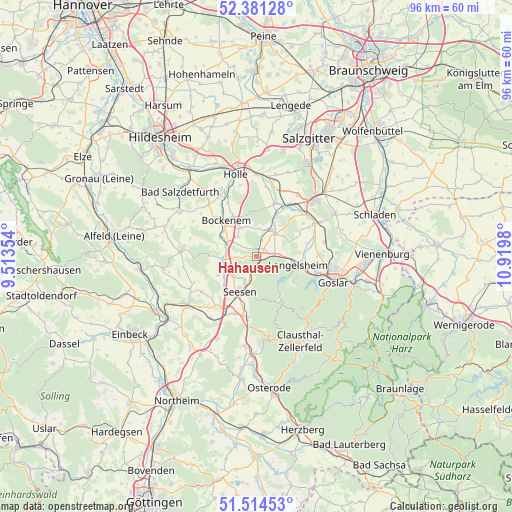
Hahausen GPS coordinates[2]
51° 57' 0" North, 10° 13' 0.012" East
| Map corner | latitude | longitude |
|---|---|---|
| Upper-left | 52.38128°, | 9.51354° |
| Center: | 51.95°, | 10.21667° |
| Lower-right: | 51.51453°, | 10.9198° |
| Map W x H: | 96.4×96.4 km | = 59.9×59.9mi |
| max Lat: | 55.01917° ⇑28.4% North |
| Hahausen: | 51.95° |
| min Lat: | ⇓71.6% South 47.40724° |
| min Long | Hahausen | max Long |
| 5.92978° | 10.21667° | 14.98853° |
| W 53.6%⇐ | ⇒46.4% E |
Elevation
Elevation of Hahausen is 207 m = 679 ft, and this is 42.1 m = 138 ft below average elevation for this country.
| Max E: |
1256 m = 4121 ft | 52.6% |
| Avg. | 249.1 m = 817 ft | |
| Hahausen | 207 m = 679 ft | |
Min E: |
-5 m = -16 ft | 47.4% |
See also: Germany elevation on elevation.city.
Geographical zone
Hahausen is located in North temperate zone (between Tropic of Cancer and the Arctic Circle). Distance of this North polar circle is 1624.9 km =1009.7 mi to North.| Distance of | km | miles | from Hahausen |
|---|---|---|---|
| North Pole | 4230.8 | 2628.9 | to North |
| Arctic Circle | 1624.9 | 1009.7 | to North |
| Tropic Cancer | 3170.4 | 1970 | to South |
| Equator | 5776.3 | 3589.2 | to South |


Nearby cities:
15 places around Hahausen: (largest is in red/bold)
• Alt Wallmoden
9.7 km =6 mi,  37°
37°
• Bad Grund
15.6 km =9.7 mi,  174°
174°
• Baddeckenstedt
14.9 km =9.3 mi,  4°
4°
• Bockenem
8.8 km =5.5 mi,  318°
318°
• Elbe
15.5 km =9.6 mi,  17°
17°
• Goslar
15.3 km =9.5 mi,  109°
109°
• Haverlah
13.4 km =8.3 mi,  345°
345°
• Heere
13.2 km =8.2 mi,  9°
9°
• Lamspringe
14.1 km =8.8 mi,  274°
274°
• Langelsheim
8.1 km =5 mi,  99°
99°
• Lutter am Barenberge
5.7 km =3.5 mi, 39°
• Neuhof
12 km =7.5 mi,  287°
287°
• Seesen
7.1 km =4.4 mi,  201°
201°
• Sehlde
10.4 km =6.5 mi, 18°
• Wildemann
14.3 km =8.9 mi,  161°
161°
Sources, notices
• [Note1] Compared only with cities in Germany existing in our database
• [Src1] Map data: © OpenStreetMap contributors (CC-BY-SA)
• [Src2] Other city data from geonames.org with taken over terms of usage.
• [Src3] Geographical zone / Annual Mean Temperature by Robert A. Rohde @ Wikipedia
