Sehlde geodata
Sehlde (Lower Saxony) is a seat of a fourth-order administrative division; located in Germany in Europe/Berlin (GMT+2) time zone. With population of 1,043 people, there are 7036 cities with bigger population in this country. Compared to other cities in Germany, 72.4% of cities are located further ↓South; 54.6% of cities are located further ←West and 62.9% of cities have higher elevation than Sehlde. Note1


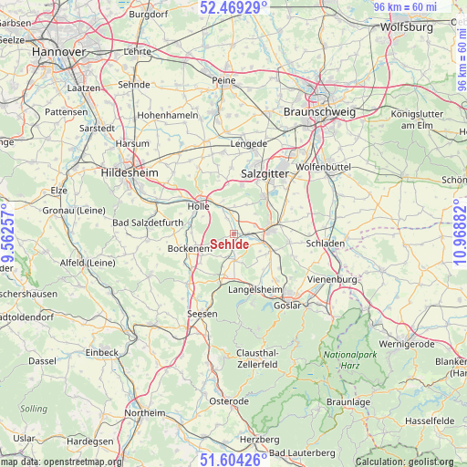
Sehlde GPS coordinates[2]
52° 2' 19.932" North, 10° 15' 56.484" East
| Map corner | latitude | longitude |
|---|---|---|
| Upper-left | 52.46929°, | 9.56257° |
| Center: | 52.03887°, | 10.26569° |
| Lower-right: | 51.60426°, | 10.96882° |
| Map W x H: | 96.2×96.2 km | = 59.8×59.8mi |
| max Lat: | 55.01917° ⇑27.6% North |
| Sehlde: | 52.03887° |
| min Lat: | ⇓72.4% South 47.40724° |
| min Long | Sehlde | max Long |
| 5.92978° | 10.26569° | 14.98853° |
| W 54.6%⇐ | ⇒45.4% E |
Elevation
Elevation of Sehlde is 133 m = 436 ft, and this is 116.1 m = 381 ft below average elevation for this country.
| Max E: |
1256 m = 4121 ft | 62.9% |
| Avg. | 249.1 m = 817 ft | |
| Sehlde | 133 m = 436 ft | |
Min E: |
-5 m = -16 ft | 37.1% |
See also: Germany elevation on elevation.city.
Geographical zone
Sehlde is located in North temperate zone (between Tropic of Cancer and the Arctic Circle). Distance of this North polar circle is 1615 km =1003.5 mi to North.| Distance of | km | miles | from Sehlde |
|---|---|---|---|
| North Pole | 4220.9 | 2622.7 | to North |
| Arctic Circle | 1615 | 1003.5 | to North |
| Tropic Cancer | 3180.3 | 1976.1 | to South |
| Equator | 5786.2 | 3595.4 | to South |


Nearby cities:
15 places around Sehlde: (largest is in red/bold)
• Alt Wallmoden
3.3 km =2.1 mi,  130°
130°
• Baddeckenstedt
5.4 km =3.4 mi,  335°
335°
• Bockenem
9.7 km =6 mi,  250°
250°
• Burgdorf
12.2 km =7.6 mi, 344°
• Cramme
14.9 km =9.3 mi,  56°
56°
• Elbe
5.1 km =3.2 mi,  13°
13°
• Flöthe
15.7 km =9.8 mi,  71°
71°
• Gielde
15.6 km =9.7 mi,  91°
91°
• Hahausen
10.4 km =6.5 mi,  198°
198°
• Haverlah
7.4 km =4.6 mi,  294°
294°
• Heere
3.3 km =2.1 mi, 340°
• Holle
9 km =5.6 mi,  306°
306°
• Langelsheim
12.1 km =7.5 mi,  157°
157°
• Liebenburg
11.5 km =7.1 mi,  99°
99°
• Lutter am Barenberge
5.5 km =3.4 mi,  177°
177°
Sources, notices
• [Note1] Compared only with cities in Germany existing in our database
• [Src1] Map data: © OpenStreetMap contributors (CC-BY-SA)
• [Src2] Other city data from geonames.org with taken over terms of usage.
• [Src3] Geographical zone / Annual Mean Temperature by Robert A. Rohde @ Wikipedia
