Heere geodata
Heere (Lower Saxony) is a seat of a fourth-order administrative division; located in Germany in Europe/Berlin (GMT+2) time zone. With population of 1,221 people, there are 6508 cities with bigger population in this country. Compared to other cities in Germany, 72.7% of cities are located further ↓South; 54.3% of cities are located further ←West and 66.2% of cities have higher elevation than Heere. Note1


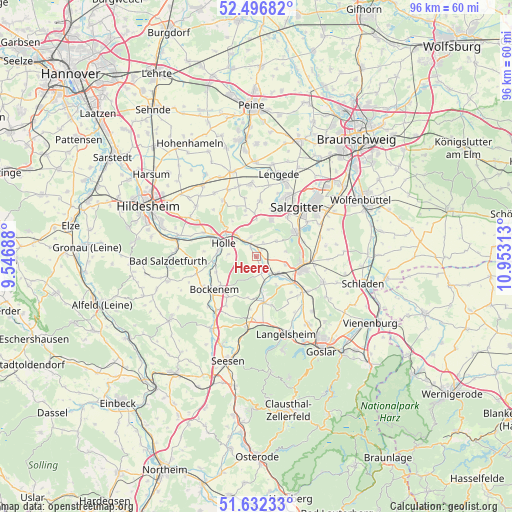
Heere GPS coordinates[2]
52° 4' 0.012" North, 10° 15' 0" East
| Map corner | latitude | longitude |
|---|---|---|
| Upper-left | 52.49682°, | 9.54688° |
| Center: | 52.06667°, | 10.25° |
| Lower-right: | 51.63233°, | 10.95313° |
| Map W x H: | 96.1×96.1 km | = 59.7×59.7mi |
| max Lat: | 55.01917° ⇑27.3% North |
| Heere: | 52.06667° |
| min Lat: | ⇓72.7% South 47.40724° |
| min Long | Heere | max Long |
| 5.92978° | 10.25° | 14.98853° |
| W 54.3%⇐ | ⇒45.7% E |
Elevation
Elevation of Heere is 113 m = 371 ft, and this is 136.1 m = 447 ft below average elevation for this country.
| Max E: |
1256 m = 4121 ft | 66.2% |
| Avg. | 249.1 m = 817 ft | |
| Heere | 113 m = 371 ft | |
Min E: |
-5 m = -16 ft | 33.8% |
See also: Germany elevation on elevation.city.
Geographical zone
Heere is located in North temperate zone (between Tropic of Cancer and the Arctic Circle). Distance of this North polar circle is 1611.9 km =1001.6 mi to North.| Distance of | km | miles | from Heere |
|---|---|---|---|
| North Pole | 4217.8 | 2620.8 | to North |
| Arctic Circle | 1611.9 | 1001.6 | to North |
| Tropic Cancer | 3183.4 | 1978.1 | to South |
| Equator | 5789.3 | 3597.3 | to South |


Nearby cities:
15 places around Heere: (largest is in red/bold)
• Alt Wallmoden
6.4 km =4 mi,  145°
145°
• Baddeckenstedt
2.2 km =1.4 mi,  328°
328°
• Bockenem
10.2 km =6.3 mi,  231°
231°
• Burgdorf
8.9 km =5.5 mi,  345°
345°
• Cramme
14.4 km =8.9 mi,  68°
68°
• Elbe
2.9 km =1.8 mi,  50°
50°
• Hahausen
13.2 km =8.2 mi,  189°
189°
• Haverlah
5.7 km =3.5 mi,  270°
270°
• Holle
6.6 km =4.1 mi,  290°
290°
• Langelsheim
15.4 km =9.6 mi,  158°
158°
• Liebenburg
13.4 km =8.3 mi,  111°
111°
• Lutter am Barenberge
8.7 km =5.4 mi,  171°
171°
• Salzgitter
15.1 km =9.4 mi, 48°
• Sehlde
3.3 km =2.1 mi, 160°
• Söhlde
13.7 km =8.5 mi, 354°
Sources, notices
• [Note1] Compared only with cities in Germany existing in our database
• [Src1] Map data: © OpenStreetMap contributors (CC-BY-SA)
• [Src2] Other city data from geonames.org with taken over terms of usage.
• [Src3] Geographical zone / Annual Mean Temperature by Robert A. Rohde @ Wikipedia
