Baddeckenstedt geodata
Baddeckenstedt (Lower Saxony) is a seat of a fourth-order administrative division; located in Germany in Europe/Berlin (GMT+2) time zone. With population of 3,278 people, there are 3771 cities with bigger population in this country. Compared to other cities in Germany, 72.8% of cities are located further ↓South; 53.9% of cities are located further ←West and 66.7% of cities have higher elevation than Baddeckenstedt. Note1
Administrative division(s):
- Level 1: Lower Saxony
- Level 3: Landkreis Wolfenbüttel
- Level 4: Baddeckenstedt


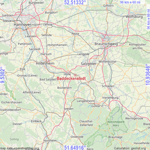
Baddeckenstedt GPS coordinates[2]
52° 4' 59.988" North, 10° 13' 59.988" East
| Map corner | latitude | longitude |
|---|---|---|
| Upper-left | 52.51332°, | 9.5302° |
| Center: | 52.08333°, | 10.23333° |
| Lower-right: | 51.64916°, | 10.93646° |
| Map W x H: | 96.1×96.1 km | = 59.7×59.7mi |
| max Lat: | 55.01917° ⇑27.2% North |
| Baddeckenstedt: | 52.08333° |
| min Lat: | ⇓72.8% South 47.40724° |
| min Long | Baddeckenstedt | max Long |
| 5.92978° | 10.23333° | 14.98853° |
| W 53.9%⇐ | ⇒46.1% E |
Elevation
Elevation of Baddeckenstedt is 110 m = 361 ft, and this is 139.1 m = 456 ft below average elevation for this country.
| Max E: |
1256 m = 4121 ft | 66.7% |
| Avg. | 249.1 m = 817 ft | |
| Baddeckenstedt | 110 m = 361 ft | |
Min E: |
-5 m = -16 ft | 33.3% |
See also: Germany elevation on elevation.city.
Geographical zone
Baddeckenstedt is located in North temperate zone (between Tropic of Cancer and the Arctic Circle). Distance of this North polar circle is 1610.1 km =1000.5 mi to North.| Distance of | km | miles | from Baddeckenstedt |
|---|---|---|---|
| North Pole | 4215.9 | 2619.6 | to North |
| Arctic Circle | 1610.1 | 1000.5 | to North |
| Tropic Cancer | 3185.2 | 1979.2 | to South |
| Equator | 5791.1 | 3598.4 | to South |


Nearby cities:
15 places around Baddeckenstedt: (largest is in red/bold)
• Alt Wallmoden
8.6 km =5.3 mi,  146°
146°
• Bockenem
10.7 km =6.6 mi,  220°
220°
• Burgdorf
6.9 km =4.3 mi,  351°
351°
• Cramme
15 km =9.3 mi,  77°
77°
• Elbe
3.4 km =2.1 mi,  90°
90°
• Hahausen
14.9 km =9.3 mi,  184°
184°
• Haverlah
4.9 km =3 mi,  247°
247°
• Heere
2.2 km =1.4 mi, 148°
• Holle
5 km =3.1 mi,  274°
274°
• Lengede
14.4 km =8.9 mi,  20°
20°
• Lutter am Barenberge
10.7 km =6.6 mi,  166°
166°
• Salzgitter
14.9 km =9.3 mi,  56°
56°
• Schellerten
14.4 km =8.9 mi,  321°
321°
• Sehlde
5.4 km =3.4 mi,  155°
155°
• Söhlde
11.7 km =7.3 mi,  359°
359°
Sources, notices
• [Note1] Compared only with cities in Germany existing in our database
• [Src1] Map data: © OpenStreetMap contributors (CC-BY-SA)
• [Src2] Other city data from geonames.org with taken over terms of usage.
• [Src3] Geographical zone / Annual Mean Temperature by Robert A. Rohde @ Wikipedia
