Güntersberge geodata
Güntersberge (Saxony-Anhalt) is a populated place; located in Germany in Europe/Berlin (GMT+2) time zone. With population of 948 people, there are 7356 cities with bigger population in this country. Compared to other cities in Germany, 68.2% of cities are located further ↓South; 66.7% of cities are located further ←West and 76.8% of cities have lower elevation than Güntersberge. Note1


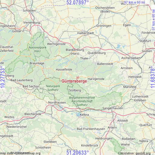
Güntersberge GPS coordinates[2]
51° 38' 41.1" North, 10° 58' 50.34" East
| Map corner | latitude | longitude |
|---|---|---|
| Upper-left | 52.07897°, | 10.27753° |
| Center: | 51.64475°, | 10.98065° |
| Lower-right: | 51.20633°, | 11.68378° |
| Map W x H: | 97×97 km | = 60.3×60.3mi |
| max Lat: | 55.01917° ⇑31.8% North |
| Güntersberge: | 51.64475° |
| min Lat: | ⇓68.2% South 47.40724° |
| min Long | Güntersberge | max Long |
| 5.92978° | 10.98065° | 14.98853° |
| W 66.7%⇐ | ⇒33.3% E |
Elevation
Elevation of Güntersberge is 411 m = 1348 ft, and this is 161.9 m = 531 ft above average elevation for this country.
| Max E: |
1256 m = 4121 ft | 23.2% |
| Güntersberge | 411 m 1348 ft | |
| Avg. | 249.1 m = 817 ft | |
Min E: |
-5 m = -16 ft | 76.8% |
See also: Germany elevation on elevation.city.
Geographical zone
Güntersberge is located in North temperate zone (between Tropic of Cancer and the Arctic Circle). Distance of this North polar circle is 1658.8 km =1030.7 mi to North.| Distance of | km | miles | from Güntersberge |
|---|---|---|---|
| North Pole | 4264.7 | 2650 | to North |
| Arctic Circle | 1658.8 | 1030.7 | to North |
| Tropic Cancer | 3136.4 | 1948.9 | to South |
| Equator | 5742.4 | 3568.2 | to South |


Nearby cities:
15 places around Güntersberge: (largest is in red/bold)
• Allrode
3.9 km =2.4 mi,  347°
347°
• Breitenstein
3.6 km =2.2 mi,  220°
220°
• Dankerode
12.5 km =7.8 mi,  118°
118°
• Friedrichsbrunn
6.4 km =4 mi,  37°
37°
• Harzgerode
11.2 km =7 mi,  91°
91°
• Hasselfelde
10.1 km =6.3 mi,  300°
300°
• Hayn
10.8 km =6.7 mi,  140°
140°
• Herrmannsacker
13.2 km =8.2 mi, 216°
• Neudorf
10.1 km =6.3 mi,  113°
113°
• Schwenda
9.8 km =6.1 mi,  163°
163°
• Siptenfelde
4.9 km =3 mi, 90°
• Stecklenberg
12.3 km =7.6 mi, 36°
• Stolberg
8 km =5 mi,  192°
192°
• Straßberg
5.7 km =3.5 mi, 124°
• Thale
12.3 km =7.6 mi,  19°
19°
Sources, notices
• [Note1] Compared only with cities in Germany existing in our database
• [Src1] Map data: © OpenStreetMap contributors (CC-BY-SA)
• [Src2] Other city data from geonames.org with taken over terms of usage.
• [Src3] Geographical zone / Annual Mean Temperature by Robert A. Rohde @ Wikipedia
