Breitenstein geodata
Breitenstein (Saxony-Anhalt) is a populated place; located in Germany in Europe/Berlin (GMT+2) time zone. With population of 516 people, there are 9283 cities with bigger population in this country. Compared to other cities in Germany, 67.9% of cities are located further ↓South; 66.2% of cities are located further ←West and 85.1% of cities have lower elevation than Breitenstein. Note1


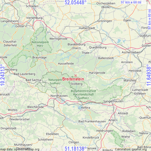
Breitenstein GPS coordinates[2]
51° 37' 12.108" North, 10° 56' 46.5" East
| Map corner | latitude | longitude |
|---|---|---|
| Upper-left | 52.05448°, | 10.24313° |
| Center: | 51.62003°, | 10.94625° |
| Lower-right: | 51.18138°, | 11.64938° |
| Map W x H: | 97.1×97.1 km | = 60.3×60.3mi |
| max Lat: | 55.01917° ⇑32.1% North |
| Breitenstein: | 51.62003° |
| min Lat: | ⇓67.9% South 47.40724° |
| min Long | Breitenstein | max Long |
| 5.92978° | 10.94625° | 14.98853° |
| W 66.2%⇐ | ⇒33.8% E |
Elevation
Elevation of Breitenstein is 470 m = 1542 ft, and this is 220.9 m = 725 ft above average elevation for this country.
| Max E: |
1256 m = 4121 ft | 14.9% |
| Breitenstein | 470 m 1542 ft | |
| Avg. | 249.1 m = 817 ft | |
Min E: |
-5 m = -16 ft | 85.1% |
See also: Germany elevation on elevation.city.
Geographical zone
Breitenstein is located in North temperate zone (between Tropic of Cancer and the Arctic Circle). Distance of this North polar circle is 1661.6 km =1032.5 mi to North.| Distance of | km | miles | from Breitenstein |
|---|---|---|---|
| North Pole | 4267.5 | 2651.7 | to North |
| Arctic Circle | 1661.6 | 1032.5 | to North |
| Tropic Cancer | 3133.7 | 1947.2 | to South |
| Equator | 5739.6 | 3566.4 | to South |


Nearby cities:
15 places around Breitenstein: (largest is in red/bold)
• Allrode
6.8 km =4.2 mi,  13°
13°
• Buchholz
11.1 km =6.9 mi,  209°
209°
• Friedrichsbrunn
10 km =6.2 mi,  38°
38°
• Güntersberge
3.6 km =2.2 mi, 40°
• Harzungen
12 km =7.5 mi,  233°
233°
• Hasselfelde
10.1 km =6.3 mi,  320°
320°
• Hayn
10.8 km =6.7 mi,  121°
121°
• Herrmannsacker
9.5 km =5.9 mi,  215°
215°
• Neudorf
11.7 km =7.3 mi,  96°
96°
• Neustadt/Harz
9.8 km =6.1 mi, 232°
• Rottleberode
11.5 km =7.1 mi,  179°
179°
• Schwenda
8.4 km =5.2 mi,  142°
142°
• Siptenfelde
7.7 km =4.8 mi,  69°
69°
• Stolberg
5.1 km =3.2 mi,  172°
172°
• Straßberg
7.1 km =4.4 mi,  93°
93°
Sources, notices
• [Note1] Compared only with cities in Germany existing in our database
• [Src1] Map data: © OpenStreetMap contributors (CC-BY-SA)
• [Src2] Other city data from geonames.org with taken over terms of usage.
• [Src3] Geographical zone / Annual Mean Temperature by Robert A. Rohde @ Wikipedia
