Herrmannsacker geodata
Herrmannsacker (Thuringia) is a seat of a fourth-order administrative division; located in Germany in Europe/Berlin (GMT+2) time zone. With population of 427 people, there are 9611 cities with bigger population in this country. Compared to other cities in Germany, 66.9% of cities are located further ↓South; 65% of cities are located further ←West and 66% of cities have lower elevation than Herrmannsacker. Note1


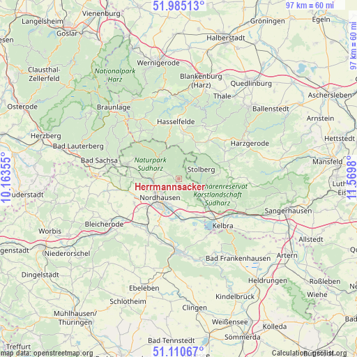
Herrmannsacker GPS coordinates[2]
51° 33' 0" North, 10° 52' 0.012" East
| Map corner | latitude | longitude |
|---|---|---|
| Upper-left | 51.98513°, | 10.16355° |
| Center: | 51.55°, | 10.86667° |
| Lower-right: | 51.11067°, | 11.5698° |
| Map W x H: | 97.2×97.2 km | = 60.4×60.4mi |
| max Lat: | 55.01917° ⇑33.1% North |
| Herrmannsacker: | 51.55° |
| min Lat: | ⇓66.9% South 47.40724° |
| min Long | Herrmannsacker | max Long |
| 5.92978° | 10.86667° | 14.98853° |
| W 65%⇐ | ⇒35% E |
Elevation
Elevation of Herrmannsacker is 328 m = 1076 ft, and this is 78.9 m = 259 ft above average elevation for this country.
| Max E: |
1256 m = 4121 ft | 34% |
| Herrmannsacker | 328 m 1076 ft | |
| Avg. | 249.1 m = 817 ft | |
Min E: |
-5 m = -16 ft | 66% |
See also: Germany elevation on elevation.city.
Geographical zone
Herrmannsacker is located in North temperate zone (between Tropic of Cancer and the Arctic Circle). Distance of this North polar circle is 1669.4 km =1037.3 mi to North.| Distance of | km | miles | from Herrmannsacker |
|---|---|---|---|
| North Pole | 4275.2 | 2656.5 | to North |
| Arctic Circle | 1669.4 | 1037.3 | to North |
| Tropic Cancer | 3125.9 | 1942.3 | to South |
| Equator | 5731.8 | 3561.6 | to South |


Nearby cities:
15 places around Herrmannsacker: (largest is in red/bold)
• Breitenstein
9.5 km =5.9 mi,  35°
35°
• Buchholz
1.9 km =1.2 mi,  180°
180°
• Görsbach
10.9 km =6.8 mi,  153°
153°
• Harzungen
4.2 km =2.6 mi,  278°
278°
• Ilfeld
6.3 km =3.9 mi,  296°
296°
• Neustadt/Harz
3 km =1.9 mi,  308°
308°
• Niedersachswerfen
7 km =4.3 mi,  270°
270°
• Nordhausen
7.3 km =4.5 mi,  222°
222°
• Rottleberode
6.7 km =4.2 mi,  124°
124°
• Schwenda
10.7 km =6.6 mi,  84°
84°
• Stolberg
6.7 km =4.2 mi,  66°
66°
• Uftrungen
9.7 km =6 mi,  125°
125°
• Urbach
8.1 km =5 mi,  162°
162°
• Uthleben
11.4 km =7.1 mi,  190°
190°
• Windehausen
9.4 km =5.8 mi, 177°
Sources, notices
• [Note1] Compared only with cities in Germany existing in our database
• [Src1] Map data: © OpenStreetMap contributors (CC-BY-SA)
• [Src2] Other city data from geonames.org with taken over terms of usage.
• [Src3] Geographical zone / Annual Mean Temperature by Robert A. Rohde @ Wikipedia
