Stolberg geodata
Stolberg (Saxony-Anhalt) is a populated place; located in Germany in Europe/Berlin (GMT+2) time zone. With population of 1,401 people, there are 6075 cities with bigger population in this country. Compared to other cities in Germany, 67.2% of cities are located further ↓South; 66.3% of cities are located further ←West and 63.8% of cities have lower elevation than Stolberg. Note1


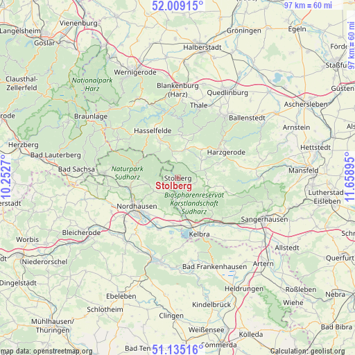
Stolberg GPS coordinates[2]
51° 34' 27.336" North, 10° 57' 20.952" East
| Map corner | latitude | longitude |
|---|---|---|
| Upper-left | 52.00915°, | 10.2527° |
| Center: | 51.57426°, | 10.95582° |
| Lower-right: | 51.13516°, | 11.65895° |
| Map W x H: | 97.2×97.2 km | = 60.4×60.4mi |
| max Lat: | 55.01917° ⇑32.8% North |
| Stolberg: | 51.57426° |
| min Lat: | ⇓67.2% South 47.40724° |
| min Long | Stolberg | max Long |
| 5.92978° | 10.95582° | 14.98853° |
| W 66.3%⇐ | ⇒33.7% E |
Elevation
Elevation of Stolberg is 314 m = 1030 ft, and this is 64.9 m = 213 ft above average elevation for this country.
| Max E: |
1256 m = 4121 ft | 36.2% |
| Stolberg | 314 m 1030 ft | |
| Avg. | 249.1 m = 817 ft | |
Min E: |
-5 m = -16 ft | 63.8% |
See also: Germany elevation on elevation.city.
Geographical zone
Stolberg is located in North temperate zone (between Tropic of Cancer and the Arctic Circle). Distance of this North polar circle is 1666.7 km =1035.6 mi to North.| Distance of | km | miles | from Stolberg |
|---|---|---|---|
| North Pole | 4272.5 | 2654.8 | to North |
| Arctic Circle | 1666.7 | 1035.6 | to North |
| Tropic Cancer | 3128.6 | 1944 | to South |
| Equator | 5734.5 | 3563.3 | to South |


Nearby cities:
15 places around Stolberg: (largest is in red/bold)
• Breitenstein
5.1 km =3.2 mi,  352°
352°
• Breitungen
10.8 km =6.7 mi,  141°
141°
• Buchholz
7.7 km =4.8 mi,  233°
233°
• Güntersberge
8 km =5 mi,  12°
12°
• Harzungen
10.5 km =6.5 mi,  258°
258°
• Hayn
8.6 km =5.3 mi,  93°
93°
• Herrmannsacker
6.7 km =4.2 mi,  246°
246°
• Neudorf
11.6 km =7.2 mi,  71°
71°
• Neustadt/Harz
8.5 km =5.3 mi, 264°
• Rottleberode
6.5 km =4 mi,  185°
185°
• Schwenda
4.8 km =3 mi,  109°
109°
• Siptenfelde
10.2 km =6.3 mi,  40°
40°
• Straßberg
7.9 km =4.9 mi,  54°
54°
• Uftrungen
8.6 km =5.3 mi,  168°
168°
• Urbach
11.1 km =6.9 mi,  199°
199°
Sources, notices
• [Note1] Compared only with cities in Germany existing in our database
• [Src1] Map data: © OpenStreetMap contributors (CC-BY-SA)
• [Src2] Other city data from geonames.org with taken over terms of usage.
• [Src3] Geographical zone / Annual Mean Temperature by Robert A. Rohde @ Wikipedia
