Grünwald geodata
Grünwald (Bavaria) is a seat of a fourth-order administrative division; located in Germany in Europe/Berlin (GMT+2) time zone. With population of 10,836 people, there are 1524 cities with bigger population in this country. Compared to other cities in Germany, 95% of cities are located further ↑North; 74.6% of cities are located further ←West and 94.8% of cities have lower elevation than Grünwald. Note1
Administrative division(s):
- Level 1: Bavaria
- Level 2: Upper Bavaria
- Level 3: Landkreis München
- Level 4: Grünwald


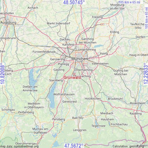
Grünwald GPS coordinates[2]
48° 2' 22.092" North, 11° 31' 23.52" East
| Map corner | latitude | longitude |
|---|---|---|
| Upper-left | 48.50745°, | 10.82008° |
| Center: | 48.03947°, | 11.5232° |
| Lower-right: | 47.5672°, | 12.22633° |
| Map W x H: | 104.5×104.5 km | = 64.9×64.9mi |
| max Lat: | 55.01917° ⇑95% North |
| Grünwald: | 48.03947° |
| min Lat: | ⇓5% South 47.40724° |
| min Long | Grünwald | max Long |
| 5.92978° | 11.5232° | 14.98853° |
| W 74.6%⇐ | ⇒25.4% E |
Elevation
Elevation of Grünwald is 595 m = 1952 ft, and this is 345.9 m = 1135 ft above average elevation for this country.
| Max E: |
1256 m = 4121 ft | 5.2% |
| Grünwald | 595 m 1952 ft | |
| Avg. | 249.1 m = 817 ft | |
Min E: |
-5 m = -16 ft | 94.8% |
See also: Germany elevation on elevation.city.
Geographical zone
Grünwald is located in North temperate zone (between Tropic of Cancer and the Arctic Circle). Distance of this North polar circle is 2059.7 km =1279.8 mi to North.| Distance of | km | miles | from Grünwald |
|---|---|---|---|
| North Pole | 4665.6 | 2899.1 | to North |
| Arctic Circle | 2059.7 | 1279.8 | to North |
| Tropic Cancer | 2735.6 | 1699.8 | to South |
| Equator | 5341.5 | 3319.1 | to South |


Nearby cities:
15 places around Grünwald: (largest is in red/bold)
• Baierbrunn
3.4 km =2.1 mi,  231°
231°
• Gauting
11.4 km =7.1 mi,  286°
286°
• Gräfelfing
11.2 km =7 mi,  321°
321°
• Krailling
11.4 km =7.1 mi,  306°
306°
• Munich
11.6 km =7.2 mi,  19°
19°
• Neubiberg
10.9 km =6.8 mi,  67°
67°
• Neuried
7.4 km =4.6 mi, 324°
• Oberhaching
5.8 km =3.6 mi,  106°
106°
• Ottobrunn
10.8 km =6.7 mi, 74°
• Planegg
10.5 km =6.5 mi, 315°
• Pullach im Isartal
2.4 km =1.5 mi,  356°
356°
• Schäftlarn
7.4 km =4.6 mi,  222°
222°
• Straßlach-Dingharting
3.9 km =2.4 mi,  189°
189°
• Taufkirchen
7 km =4.3 mi,  81°
81°
• Unterhaching
7.5 km =4.7 mi, 66°
Sources, notices
• [Note1] Compared only with cities in Germany existing in our database
• [Src1] Map data: © OpenStreetMap contributors (CC-BY-SA)
• [Src2] Other city data from geonames.org with taken over terms of usage.
• [Src3] Geographical zone / Annual Mean Temperature by Robert A. Rohde @ Wikipedia
