Straßlach-Dingharting geodata
Straßlach-Dingharting (Bavaria) is a seat of a fourth-order administrative division; located in Germany in Europe/Berlin (GMT+2) time zone. With population of 2,899 people, there are 4093 cities with bigger population in this country. Compared to other cities in Germany, 95.5% of cities are located further ↑North; 74.5% of cities are located further ←West and 96.2% of cities have lower elevation than Straßlach-Dingharting. Note1
Administrative division(s):
- Level 1: Bavaria
- Level 2: Upper Bavaria
- Level 3: Landkreis München
- Level 4: Straßlach-Dingharting


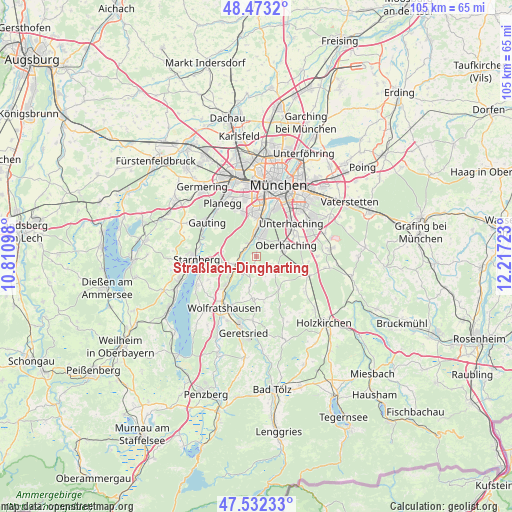
Straßlach-Dingharting GPS coordinates[2]
48° 0' 17.676" North, 11° 30' 50.76" East
| Map corner | latitude | longitude |
|---|---|---|
| Upper-left | 48.4732°, | 10.81098° |
| Center: | 48.00491°, | 11.5141° |
| Lower-right: | 47.53233°, | 12.21723° |
| Map W x H: | 104.6×104.6 km | = 65×65mi |
| max Lat: | 55.01917° ⇑95.5% North |
| Straßlach-Dingharting: | 48.00491° |
| min Lat: | ⇓4.5% South 47.40724° |
| min Long | Straßlach-Ding | max Long |
| 5.92978° | 11.5141° | 14.98853° |
| W 74.5%⇐ | ⇒25.5% E |
Elevation
Elevation of Straßlach-Dingharting is 634 m = 2080 ft, and this is 384.9 m = 1263 ft above average elevation for this country.
| Max E: |
1256 m = 4121 ft | 3.8% |
| Straßlach-Dingharting | 634 m 2080 ft | |
| Avg. | 249.1 m = 817 ft | |
Min E: |
-5 m = -16 ft | 96.2% |
See also: Germany elevation on elevation.city.
Geographical zone
Straßlach-Dingharting is located in North temperate zone (between Tropic of Cancer and the Arctic Circle). Distance of this North polar circle is 2063.5 km =1282.2 mi to North.| Distance of | km | miles | from Straßlach-Dingharting |
|---|---|---|---|
| North Pole | 4669.4 | 2901.4 | to North |
| Arctic Circle | 2063.5 | 1282.2 | to North |
| Tropic Cancer | 2731.7 | 1697.4 | to South |
| Equator | 5337.6 | 3316.6 | to South |


Nearby cities:
15 places around Straßlach-Dingharting: (largest is in red/bold)
• Baierbrunn
2.7 km =1.7 mi,  310°
310°
• Brunnthal
12.6 km =7.8 mi,  89°
89°
• Egling
9.1 km =5.7 mi,  184°
184°
• Gauting
12.4 km =7.7 mi, 305°
• Grünwald
3.9 km =2.4 mi,  9°
9°
• Icking
8.6 km =5.3 mi,  224°
224°
• Neuried
10.5 km =6.5 mi,  339°
339°
• Oberhaching
6.6 km =4.1 mi,  70°
70°
• Pullach im Isartal
6.3 km =3.9 mi, 5°
• Reichertshausen
12.2 km =7.6 mi,  164°
164°
• Sauerlach
11 km =6.8 mi,  109°
109°
• Schäftlarn
4.6 km =2.9 mi,  249°
249°
• Taufkirchen
9.1 km =5.7 mi,  57°
57°
• Unterhaching
10.2 km =6.3 mi,  48°
48°
• Wolfratshausen
12.3 km =7.6 mi,  213°
213°
Sources, notices
• [Note1] Compared only with cities in Germany existing in our database
• [Src1] Map data: © OpenStreetMap contributors (CC-BY-SA)
• [Src2] Other city data from geonames.org with taken over terms of usage.
• [Src3] Geographical zone / Annual Mean Temperature by Robert A. Rohde @ Wikipedia
