Baierbrunn geodata
Baierbrunn (Bavaria) is a seat of a fourth-order administrative division; located in Germany in Europe/Berlin (GMT+2) time zone. With population of 2,755 people, there are 4189 cities with bigger population in this country. Compared to other cities in Germany, 95.2% of cities are located further ↑North; 74.1% of cities are located further ←West and 95.8% of cities have lower elevation than Baierbrunn. Note1
Administrative division(s):
- Level 1: Bavaria
- Level 2: Upper Bavaria
- Level 3: Landkreis München
- Level 4: Baierbrunn


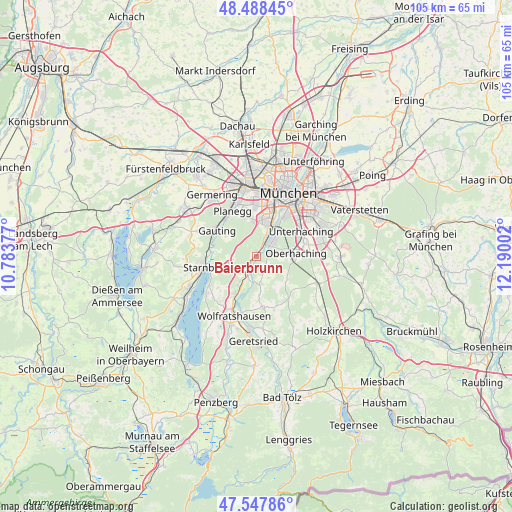
Baierbrunn GPS coordinates[2]
48° 1' 13.08" North, 11° 29' 12.804" East
| Map corner | latitude | longitude |
|---|---|---|
| Upper-left | 48.48845°, | 10.78377° |
| Center: | 48.0203°, | 11.48689° |
| Lower-right: | 47.54786°, | 12.19002° |
| Map W x H: | 104.6×104.6 km | = 65×65mi |
| max Lat: | 55.01917° ⇑95.2% North |
| Baierbrunn: | 48.0203° |
| min Lat: | ⇓4.8% South 47.40724° |
| min Long | Baierbrunn | max Long |
| 5.92978° | 11.48689° | 14.98853° |
| W 74.1%⇐ | ⇒25.9% E |
Elevation
Elevation of Baierbrunn is 619 m = 2031 ft, and this is 369.9 m = 1214 ft above average elevation for this country.
| Max E: |
1256 m = 4121 ft | 4.2% |
| Baierbrunn | 619 m 2031 ft | |
| Avg. | 249.1 m = 817 ft | |
Min E: |
-5 m = -16 ft | 95.8% |
See also: Germany elevation on elevation.city.
Geographical zone
Baierbrunn is located in North temperate zone (between Tropic of Cancer and the Arctic Circle). Distance of this North polar circle is 2061.8 km =1281.1 mi to North.| Distance of | km | miles | from Baierbrunn |
|---|---|---|---|
| North Pole | 4667.7 | 2900.4 | to North |
| Arctic Circle | 2061.8 | 1281.1 | to North |
| Tropic Cancer | 2733.4 | 1698.5 | to South |
| Equator | 5339.4 | 3317.7 | to South |


Nearby cities:
15 places around Baierbrunn: (largest is in red/bold)
• Berg
11.5 km =7.1 mi,  239°
239°
• Egling
10.9 km =6.8 mi,  172°
172°
• Gauting
9.8 km =6.1 mi,  303°
303°
• Grünwald
3.4 km =2.1 mi,  51°
51°
• Icking
8.8 km =5.5 mi,  207°
207°
• Krailling
11 km =6.8 mi,  323°
323°
• Neuried
8.3 km =5.2 mi,  348°
348°
• Oberhaching
8.2 km =5.1 mi,  86°
86°
• Planegg
10.7 km =6.6 mi,  334°
334°
• Pullach im Isartal
5.2 km =3.2 mi,  29°
29°
• Schäftlarn
4.1 km =2.5 mi, 214°
• Starnberg
10.8 km =6.7 mi,  259°
259°
• Straßlach-Dingharting
2.7 km =1.7 mi,  130°
130°
• Taufkirchen
10.2 km =6.3 mi,  71°
71°
• Unterhaching
10.8 km =6.7 mi,  62°
62°
Sources, notices
• [Note1] Compared only with cities in Germany existing in our database
• [Src1] Map data: © OpenStreetMap contributors (CC-BY-SA)
• [Src2] Other city data from geonames.org with taken over terms of usage.
• [Src3] Geographical zone / Annual Mean Temperature by Robert A. Rohde @ Wikipedia
