Oberhaching geodata
Oberhaching (Bavaria) is a seat of a fourth-order administrative division; located in Germany in Europe/Berlin (GMT+2) time zone. With population of 12,470 people, there are 1306 cities with bigger population in this country. Compared to other cities in Germany, 95.2% of cities are located further ↑North; 75.7% of cities are located further ←West and 94.3% of cities have lower elevation than Oberhaching. Note1
Administrative division(s):
- Level 1: Bavaria
- Level 2: Upper Bavaria
- Level 3: Landkreis München
- Level 4: Oberhaching


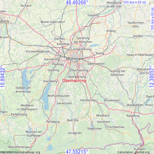
Oberhaching GPS coordinates[2]
48° 1' 28.38" North, 11° 35' 50.784" East
| Map corner | latitude | longitude |
|---|---|---|
| Upper-left | 48.49266°, | 10.89432° |
| Center: | 48.02455°, | 11.59744° |
| Lower-right: | 47.55215°, | 12.30057° |
| Map W x H: | 104.6×104.6 km | = 65×65mi |
| max Lat: | 55.01917° ⇑95.2% North |
| Oberhaching: | 48.02455° |
| min Lat: | ⇓4.8% South 47.40724° |
| min Long | Oberhaching | max Long |
| 5.92978° | 11.59744° | 14.98853° |
| W 75.7%⇐ | ⇒24.3% E |
Elevation
Elevation of Oberhaching is 581 m = 1906 ft, and this is 331.9 m = 1089 ft above average elevation for this country.
| Max E: |
1256 m = 4121 ft | 5.7% |
| Oberhaching | 581 m 1906 ft | |
| Avg. | 249.1 m = 817 ft | |
Min E: |
-5 m = -16 ft | 94.3% |
See also: Germany elevation on elevation.city.
Geographical zone
Oberhaching is located in North temperate zone (between Tropic of Cancer and the Arctic Circle). Distance of this North polar circle is 2061.3 km =1280.8 mi to North.| Distance of | km | miles | from Oberhaching |
|---|---|---|---|
| North Pole | 4667.2 | 2900.1 | to North |
| Arctic Circle | 2061.3 | 1280.8 | to North |
| Tropic Cancer | 2733.9 | 1698.8 | to South |
| Equator | 5339.8 | 3318 | to South |


Nearby cities:
15 places around Oberhaching: (largest is in red/bold)
• Baierbrunn
8.2 km =5.1 mi,  266°
266°
• Brunnthal
6.7 km =4.2 mi,  107°
107°
• Grasbrunn
12.4 km =7.7 mi,  60°
60°
• Grünwald
5.8 km =3.6 mi,  286°
286°
• Hohenbrunn
8.2 km =5.1 mi,  71°
71°
• Höhenkirchen-Siegertsbrunn
9.1 km =5.7 mi,  93°
93°
• Neubiberg
7.4 km =4.6 mi,  37°
37°
• Ottobrunn
6.6 km =4.1 mi,  47°
47°
• Pullach im Isartal
7 km =4.3 mi,  305°
305°
• Putzbrunn
10.5 km =6.5 mi, 57°
• Sauerlach
7.2 km =4.5 mi,  144°
144°
• Schäftlarn
11.2 km =7 mi,  250°
250°
• Straßlach-Dingharting
6.6 km =4.1 mi, 250°
• Taufkirchen
3 km =1.9 mi,  28°
28°
• Unterhaching
4.8 km =3 mi,  16°
16°
Sources, notices
• [Note1] Compared only with cities in Germany existing in our database
• [Src1] Map data: © OpenStreetMap contributors (CC-BY-SA)
• [Src2] Other city data from geonames.org with taken over terms of usage.
• [Src3] Geographical zone / Annual Mean Temperature by Robert A. Rohde @ Wikipedia
