Lützelbach geodata
Lützelbach (Hesse) is a seat of a fourth-order administrative division; located in Germany in Europe/Berlin (GMT+2) time zone. In our database, there are 11009 cities with bigger population. Compared to other cities in Germany, 69.2% of cities are located further ↑North; 64.4% of cities are located further →East and 53.2% of cities have lower elevation than Lützelbach. Note1
Administrative division(s):
- Level 1: Hesse
- Level 2: Regierungsbezirk Darmstadt
- Level 3: Odenwaldkreis
- Level 4: Lützelbach


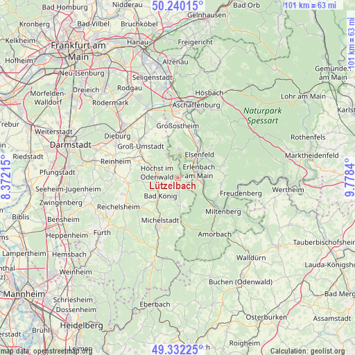
Lützelbach GPS coordinates[2]
49° 47' 17.988" North, 9° 4' 31.008" East
| Map corner | latitude | longitude |
|---|---|---|
| Upper-left | 50.24015°, | 8.37215° |
| Center: | 49.78833°, | 9.07528° |
| Lower-right: | 49.33225°, | 9.7784° |
| Map W x H: | 100.9×100.9 km | = 62.7×62.7mi |
| max Lat: | 55.01917° ⇑69.2% North |
| Lützelbach: | 49.78833° |
| min Lat: | ⇓30.8% South 47.40724° |
| min Long | Lützelbach | max Long |
| 5.92978° | 9.07528° | 14.98853° |
| W 35.6%⇐ | ⇒64.4% E |
Elevation
Elevation of Lützelbach is 248 m = 814 ft, and this is 1.1 m = 4 ft below average elevation for this country.
| Max E: |
1256 m = 4121 ft | 46.8% |
| Avg. | 249.1 m = 817 ft | |
| Lützelbach | 248 m = 814 ft | |
Min E: |
-5 m = -16 ft | 53.2% |
See also: Germany elevation on elevation.city.
Geographical zone
Lützelbach is located in North temperate zone (between Tropic of Cancer and the Arctic Circle). Distance of this North polar circle is 1865.2 km =1159 mi to North.| Distance of | km | miles | from Lützelbach |
|---|---|---|---|
| North Pole | 4471.1 | 2778.2 | to North |
| Arctic Circle | 1865.2 | 1159 | to North |
| Tropic Cancer | 2930 | 1820.6 | to South |
| Equator | 5535.9 | 3439.8 | to South |


Nearby cities:
15 places around Lützelbach: (largest is in red/bold)
• Bad König
7 km =4.3 mi,  224°
224°
• Elsenfeld
8.8 km =5.5 mi,  46°
46°
• Erlenbach am Main
6.5 km =4 mi,  75°
75°
• Großwallstadt
11.6 km =7.2 mi,  28°
28°
• Höchst im Odenwald
5.6 km =3.5 mi,  283°
283°
• Kleinheubach
12.4 km =7.7 mi,  126°
126°
• Kleinwallstadt
11.7 km =7.3 mi,  35°
35°
• Klingenberg am Main
7.5 km =4.7 mi,  92°
92°
• Laudenbach
8.6 km =5.3 mi,  123°
123°
• Mömlingen
8 km =5 mi,  4°
4°
• Obernburg am Main
6.6 km =4.1 mi, 37°
• Röllbach
12.4 km =7.7 mi,  97°
97°
• Rüdenau
11.4 km =7.1 mi,  138°
138°
• Weiten-Gesäß
9.8 km =6.1 mi,  190°
190°
• Wörth am Main
5.7 km =3.5 mi, 80°
Sources, notices
• [Note1] Compared only with cities in Germany existing in our database
• [Src1] Map data: © OpenStreetMap contributors (CC-BY-SA)
• [Src2] Other city data from geonames.org with taken over terms of usage.
• [Src3] Geographical zone / Annual Mean Temperature by Robert A. Rohde @ Wikipedia
