Großheirath geodata
Großheirath (Bavaria) is a seat of a fourth-order administrative division; located in Germany in Europe/Berlin (GMT+2) time zone. With population of 2,640 people, there are 4295 cities with bigger population in this country. Compared to other cities in Germany, 59.5% of cities are located further ↑North; 66.3% of cities are located further ←West and 59.1% of cities have lower elevation than Großheirath. Note1
Administrative division(s):
- Level 1: Bavaria
- Level 2: Upper Franconia
- Level 3: Landkreis Coburg
- Level 4: Großheirath


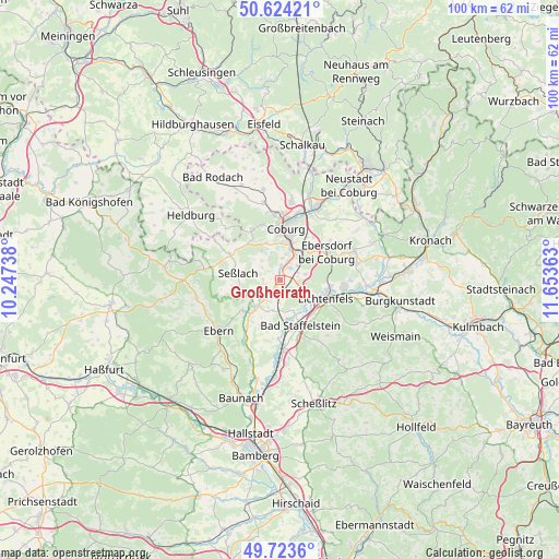
Großheirath GPS coordinates[2]
50° 10' 33.708" North, 10° 57' 1.8" East
| Map corner | latitude | longitude |
|---|---|---|
| Upper-left | 50.62421°, | 10.24738° |
| Center: | 50.17603°, | 10.9505° |
| Lower-right: | 49.7236°, | 11.65363° |
| Map W x H: | 100.1×100.1 km | = 62.2×62.2mi |
| max Lat: | 55.01917° ⇑59.5% North |
| Großheirath: | 50.17603° |
| min Lat: | ⇓40.5% South 47.40724° |
| min Long | Großheirath | max Long |
| 5.92978° | 10.9505° | 14.98853° |
| W 66.3%⇐ | ⇒33.7% E |
Elevation
Elevation of Großheirath is 284 m = 932 ft, and this is 34.9 m = 115 ft above average elevation for this country.
| Max E: |
1256 m = 4121 ft | 40.9% |
| Großheirath | 284 m 932 ft | |
| Avg. | 249.1 m = 817 ft | |
Min E: |
-5 m = -16 ft | 59.1% |
See also: Germany elevation on elevation.city.
Geographical zone
Großheirath is located in North temperate zone (between Tropic of Cancer and the Arctic Circle). Distance of this North polar circle is 1822.1 km =1132.2 mi to North.| Distance of | km | miles | from Großheirath |
|---|---|---|---|
| North Pole | 4428 | 2751.4 | to North |
| Arctic Circle | 1822.1 | 1132.2 | to North |
| Tropic Cancer | 2973.1 | 1847.4 | to South |
| Equator | 5579.1 | 3466.7 | to South |


Nearby cities:
15 places around Großheirath: (largest is in red/bold)
• Ahorn
6.9 km =4.3 mi,  2°
2°
• Bad Staffelstein
9 km =5.6 mi,  156°
156°
• Coburg
9.3 km =5.8 mi,  5°
5°
• Ebensfeld
12.2 km =7.6 mi,  177°
177°
• Lichtenfels
8.5 km =5.3 mi,  113°
113°
• Michelau
11.6 km =7.2 mi,  97°
97°
• Niederfüllbach
5.7 km =3.5 mi,  30°
30°
• Rödental
14.7 km =9.1 mi, 25°
• Seßlach
7.9 km =4.9 mi,  281°
281°
• Sonnefeld
13.8 km =8.6 mi,  70°
70°
• Ummerstadt
13.5 km =8.4 mi,  312°
312°
• Untermerzbach
8.6 km =5.3 mi,  231°
231°
• Untersiemau
2.6 km =1.6 mi,  40°
40°
• Weidhausen bei Coburg
13.8 km =8.6 mi,  77°
77°
• Weitramsdorf
10.2 km =6.3 mi,  330°
330°
Sources, notices
• [Note1] Compared only with cities in Germany existing in our database
• [Src1] Map data: © OpenStreetMap contributors (CC-BY-SA)
• [Src2] Other city data from geonames.org with taken over terms of usage.
• [Src3] Geographical zone / Annual Mean Temperature by Robert A. Rohde @ Wikipedia
