Seßlach geodata
Seßlach (Bavaria) is a populated place; located in Germany in Europe/Berlin (GMT+2) time zone. With population of 4,088 people, there are 3243 cities with bigger population in this country. Compared to other cities in Germany, 59.2% of cities are located further ↑North; 64.7% of cities are located further ←West and 58.1% of cities have lower elevation than Seßlach. Note1
Administrative division(s):
- Level 1: Bavaria
- Level 2: Upper Franconia
- Level 3: Landkreis Coburg
- Level 4: Seßlach


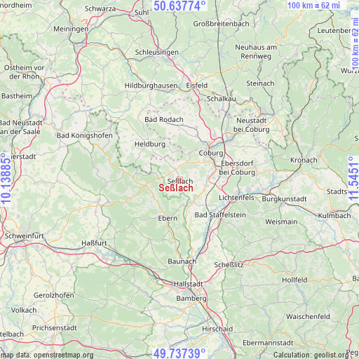
Seßlach GPS coordinates[2]
50° 11' 22.884" North, 10° 50' 31.092" East
| Map corner | latitude | longitude |
|---|---|---|
| Upper-left | 50.63774°, | 10.13885° |
| Center: | 50.18969°, | 10.84197° |
| Lower-right: | 49.73739°, | 11.5451° |
| Map W x H: | 100.1×100.1 km | = 62.2×62.2mi |
| max Lat: | 55.01917° ⇑59.2% North |
| Seßlach: | 50.18969° |
| min Lat: | ⇓40.8% South 47.40724° |
| min Long | Seßlach | max Long |
| 5.92978° | 10.84197° | 14.98853° |
| W 64.7%⇐ | ⇒35.3% E |
Elevation
Elevation of Seßlach is 279 m = 915 ft, and this is 29.9 m = 98 ft above average elevation for this country.
| Max E: |
1256 m = 4121 ft | 41.9% |
| Seßlach | 279 m 915 ft | |
| Avg. | 249.1 m = 817 ft | |
Min E: |
-5 m = -16 ft | 58.1% |
See also: Germany elevation on elevation.city.
Geographical zone
Seßlach is located in North temperate zone (between Tropic of Cancer and the Arctic Circle). Distance of this North polar circle is 1820.6 km =1131.3 mi to North.| Distance of | km | miles | from Seßlach |
|---|---|---|---|
| North Pole | 4426.5 | 2750.5 | to North |
| Arctic Circle | 1820.6 | 1131.3 | to North |
| Tropic Cancer | 2974.7 | 1848.4 | to South |
| Equator | 5580.6 | 3467.6 | to South |


Nearby cities:
15 places around Seßlach: (largest is in red/bold)
• Ahorn
9.6 km =6 mi,  56°
56°
• Bad Staffelstein
15 km =9.3 mi,  130°
130°
• Burgpreppach
14.7 km =9.1 mi,  248°
248°
• Coburg
11.6 km =7.2 mi,  48°
48°
• Großheirath
7.9 km =4.9 mi,  101°
101°
• Hellingen
13.1 km =8.1 mi,  300°
300°
• Maroldsweisach
13 km =8.1 mi,  272°
272°
• Meeder
15.3 km =9.5 mi,  17°
17°
• Niederfüllbach
11.1 km =6.9 mi,  72°
72°
• Pfarrweisach
8.9 km =5.5 mi,  240°
240°
• Rentweinsdorf
14.4 km =8.9 mi,  192°
192°
• Ummerstadt
8 km =5 mi,  344°
344°
• Untermerzbach
7 km =4.3 mi,  171°
171°
• Untersiemau
9.4 km =5.8 mi,  86°
86°
• Weitramsdorf
7.9 km =4.9 mi, 20°
Sources, notices
• [Note1] Compared only with cities in Germany existing in our database
• [Src1] Map data: © OpenStreetMap contributors (CC-BY-SA)
• [Src2] Other city data from geonames.org with taken over terms of usage.
• [Src3] Geographical zone / Annual Mean Temperature by Robert A. Rohde @ Wikipedia
