Rödental geodata
Rödental (Bavaria) is a populated place; located in Germany in Europe/Berlin (GMT+2) time zone. With population of 13,712 people, there are 1169 cities with bigger population in this country. Compared to other cities in Germany, 56.9% of cities are located further ↑North; 67.5% of cities are located further ←West and 67.6% of cities have lower elevation than Rödental. Note1
Administrative division(s):
- Level 1: Bavaria
- Level 2: Upper Franconia
- Level 3: Landkreis Coburg
- Level 4: Rödental


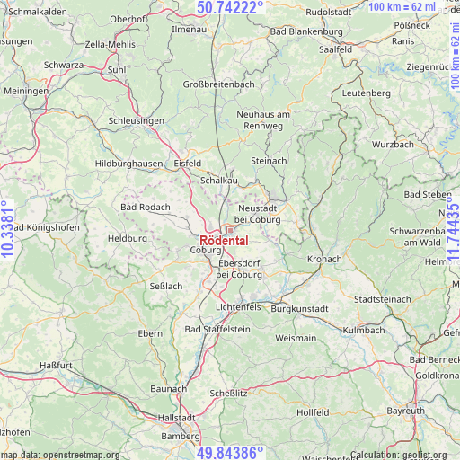
Rödental GPS coordinates[2]
50° 17' 42.576" North, 11° 2' 28.392" East
| Map corner | latitude | longitude |
|---|---|---|
| Upper-left | 50.74222°, | 10.3381° |
| Center: | 50.29516°, | 11.04122° |
| Lower-right: | 49.84386°, | 11.74435° |
| Map W x H: | 99.9×99.9 km | = 62.1×62.1mi |
| max Lat: | 55.01917° ⇑56.9% North |
| Rödental: | 50.29516° |
| min Lat: | ⇓43.1% South 47.40724° |
| min Long | Rödental | max Long |
| 5.92978° | 11.04122° | 14.98853° |
| W 67.5%⇐ | ⇒32.5% E |
Elevation
Elevation of Rödental is 340 m = 1115 ft, and this is 90.9 m = 298 ft above average elevation for this country.
| Max E: |
1256 m = 4121 ft | 32.4% |
| Rödental | 340 m 1115 ft | |
| Avg. | 249.1 m = 817 ft | |
Min E: |
-5 m = -16 ft | 67.6% |
See also: Germany elevation on elevation.city.
Geographical zone
Rödental is located in North temperate zone (between Tropic of Cancer and the Arctic Circle). Distance of this North polar circle is 1808.9 km =1124 mi to North.| Distance of | km | miles | from Rödental |
|---|---|---|---|
| North Pole | 4414.8 | 2743.2 | to North |
| Arctic Circle | 1808.9 | 1124 | to North |
| Tropic Cancer | 2986.4 | 1855.7 | to South |
| Equator | 5592.3 | 3474.9 | to South |


Nearby cities:
15 places around Rödental: (largest is in red/bold)
• Ahorn
8.9 km =5.5 mi,  224°
224°
• Coburg
6.8 km =4.2 mi,  234°
234°
• Ebersdorf
8.8 km =5.5 mi,  64°
64°
• Lautertal
6.8 km =4.2 mi,  308°
308°
• Meeder
10 km =6.2 mi,  286°
286°
• Mengersgereuth-Hämmern
12.6 km =7.8 mi,  25°
25°
• Mitwitz
12.8 km =8 mi,  112°
112°
• Neustadt bei Coburg
6.8 km =4.2 mi, 55°
• Niederfüllbach
9.1 km =5.7 mi,  203°
203°
• Schalkau
11.4 km =7.1 mi,  347°
347°
• Sonneberg
11.8 km =7.3 mi,  53°
53°
• Sonnefeld
10.9 km =6.8 mi,  143°
143°
• Untersiemau
12.2 km =7.6 mi, 202°
• Weidhausen bei Coburg
12.4 km =7.7 mi,  145°
145°
• Weitramsdorf
12.3 km =7.6 mi,  249°
249°
Sources, notices
• [Note1] Compared only with cities in Germany existing in our database
• [Src1] Map data: © OpenStreetMap contributors (CC-BY-SA)
• [Src2] Other city data from geonames.org with taken over terms of usage.
• [Src3] Geographical zone / Annual Mean Temperature by Robert A. Rohde @ Wikipedia
