Ebensfeld geodata
Ebensfeld (Bavaria) is a populated place; located in Germany in Europe/Berlin (GMT+2) time zone. With population of 5,721 people, there are 2554 cities with bigger population in this country. Compared to other cities in Germany, 62.2% of cities are located further ↑North; 66.4% of cities are located further ←West and 55.2% of cities have lower elevation than Ebensfeld. Note1
Administrative division(s):
- Level 1: Bavaria
- Level 2: Upper Franconia
- Level 3: Landkreis Lichtenfels
- Level 4: Ebensfeld, Markt


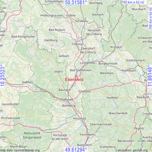
Ebensfeld GPS coordinates[2]
50° 3' 59.04" North, 10° 57' 30.06" East
| Map corner | latitude | longitude |
|---|---|---|
| Upper-left | 50.51561°, | 10.25523° |
| Center: | 50.0664°, | 10.95835° |
| Lower-right: | 49.61294°, | 11.66148° |
| Map W x H: | 100.4×100.4 km | = 62.4×62.4mi |
| max Lat: | 55.01917° ⇑62.2% North |
| Ebensfeld: | 50.0664° |
| min Lat: | ⇓37.8% South 47.40724° |
| min Long | Ebensfeld | max Long |
| 5.92978° | 10.95835° | 14.98853° |
| W 66.4%⇐ | ⇒33.6% E |
Elevation
Elevation of Ebensfeld is 259 m = 850 ft, and this is 9.9 m = 32 ft above average elevation for this country.
| Max E: |
1256 m = 4121 ft | 44.8% |
| Ebensfeld | 259 m 850 ft | |
| Avg. | 249.1 m = 817 ft | |
Min E: |
-5 m = -16 ft | 55.2% |
See also: Germany elevation on elevation.city.
Geographical zone
Ebensfeld is located in North temperate zone (between Tropic of Cancer and the Arctic Circle). Distance of this North polar circle is 1834.3 km =1139.8 mi to North.| Distance of | km | miles | from Ebensfeld |
|---|---|---|---|
| North Pole | 4440.2 | 2759 | to North |
| Arctic Circle | 1834.3 | 1139.8 | to North |
| Tropic Cancer | 2960.9 | 1839.8 | to South |
| Equator | 5566.9 | 3459.1 | to South |


Nearby cities:
15 places around Ebensfeld: (largest is in red/bold)
• Bad Staffelstein
5 km =3.1 mi,  37°
37°
• Baunach
11.7 km =7.3 mi,  220°
220°
• Breitengüßbach
11.7 km =7.3 mi,  206°
206°
• Gerach
11.9 km =7.4 mi,  251°
251°
• Großheirath
12.2 km =7.6 mi,  357°
357°
• Kemmern
13.7 km =8.5 mi,  204°
204°
• Lichtenfels
11.4 km =7.1 mi, 39°
• Rattelsdorf
7.6 km =4.7 mi, 221°
• Reckendorf
10.5 km =6.5 mi,  238°
238°
• Rentweinsdorf
11.4 km =7.1 mi,  268°
268°
• Scheßlitz
11.4 km =7.1 mi,  152°
152°
• Untermerzbach
10 km =6.2 mi,  313°
313°
• Untersiemau
14.3 km =8.9 mi,  4°
4°
• Wattendorf
12.6 km =7.8 mi,  107°
107°
• Zapfendorf
5.7 km =3.5 mi, 198°
Sources, notices
• [Note1] Compared only with cities in Germany existing in our database
• [Src1] Map data: © OpenStreetMap contributors (CC-BY-SA)
• [Src2] Other city data from geonames.org with taken over terms of usage.
• [Src3] Geographical zone / Annual Mean Temperature by Robert A. Rohde @ Wikipedia
