Weitramsdorf geodata
Weitramsdorf (Bavaria) is a seat of a fourth-order administrative division; located in Germany in Europe/Berlin (GMT+2) time zone. With population of 5,183 people, there are 2749 cities with bigger population in this country. Compared to other cities in Germany, 57.7% of cities are located further ↑North; 65.2% of cities are located further ←West and 62.3% of cities have lower elevation than Weitramsdorf. Note1
Administrative division(s):
- Level 1: Bavaria
- Level 2: Upper Franconia
- Level 3: Landkreis Coburg
- Level 4: Weitramsdorf


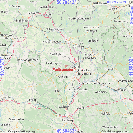
Weitramsdorf GPS coordinates[2]
50° 15' 21.6" North, 10° 52' 47.604" East
| Map corner | latitude | longitude |
|---|---|---|
| Upper-left | 50.70343°, | 10.17677° |
| Center: | 50.256°, | 10.87989° |
| Lower-right: | 49.80433°, | 11.58302° |
| Map W x H: | 100×100 km | = 62.1×62.1mi |
| max Lat: | 55.01917° ⇑57.7% North |
| Weitramsdorf: | 50.256° |
| min Lat: | ⇓42.3% South 47.40724° |
| min Long | Weitramsdorf | max Long |
| 5.92978° | 10.87989° | 14.98853° |
| W 65.2%⇐ | ⇒34.8% E |
Elevation
Elevation of Weitramsdorf is 304 m = 997 ft, and this is 54.9 m = 180 ft above average elevation for this country.
| Max E: |
1256 m = 4121 ft | 37.7% |
| Weitramsdorf | 304 m 997 ft | |
| Avg. | 249.1 m = 817 ft | |
Min E: |
-5 m = -16 ft | 62.3% |
See also: Germany elevation on elevation.city.
Geographical zone
Weitramsdorf is located in North temperate zone (between Tropic of Cancer and the Arctic Circle). Distance of this North polar circle is 1813.2 km =1126.7 mi to North.| Distance of | km | miles | from Weitramsdorf |
|---|---|---|---|
| North Pole | 4419.1 | 2745.9 | to North |
| Arctic Circle | 1813.2 | 1126.7 | to North |
| Tropic Cancer | 2982 | 1852.9 | to South |
| Equator | 5587.9 | 3472.2 | to South |


Nearby cities:
15 places around Weitramsdorf: (largest is in red/bold)
• Ahorn
5.7 km =3.5 mi,  111°
111°
• Bockstadt
16 km =9.9 mi,  0°
0°
• Coburg
6 km =3.7 mi,  86°
86°
• Großheirath
10.2 km =6.3 mi,  150°
150°
• Hellingen
14 km =8.7 mi,  267°
267°
• Lautertal
10.6 km =6.6 mi,  35°
35°
• Meeder
7.5 km =4.7 mi,  14°
14°
• Niederfüllbach
8.8 km =5.5 mi,  116°
116°
• Pfarrweisach
15.7 km =9.8 mi,  221°
221°
• Rödental
12.3 km =7.6 mi,  69°
69°
• Seßlach
7.9 km =4.9 mi,  200°
200°
• Ummerstadt
4.9 km =3 mi, 273°
• Untermerzbach
14.4 km =8.9 mi,  186°
186°
• Untersiemau
9.6 km =6 mi,  135°
135°
• Westhausen
16.8 km =10.4 mi,  293°
293°
Sources, notices
• [Note1] Compared only with cities in Germany existing in our database
• [Src1] Map data: © OpenStreetMap contributors (CC-BY-SA)
• [Src2] Other city data from geonames.org with taken over terms of usage.
• [Src3] Geographical zone / Annual Mean Temperature by Robert A. Rohde @ Wikipedia
