Großeibstadt geodata
Großeibstadt (Bavaria) is a seat of a fourth-order administrative division; located in Germany in Europe/Berlin (GMT+2) time zone. With population of 1,199 people, there are 6566 cities with bigger population in this country. Compared to other cities in Germany, 56.7% of cities are located further ↑North; 57.2% of cities are located further ←West and 58.8% of cities have lower elevation than Großeibstadt. Note1
Administrative division(s):
- Level 1: Bavaria
- Level 2: Regierungsbezirk Unterfranken
- Level 3: Landkreis Rhön-Grabfeld
- Level 4: Großeibstadt


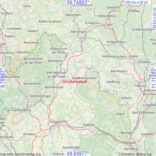
Großeibstadt GPS coordinates[2]
50° 18' 3.672" North, 10° 24' 35.28" East
| Map corner | latitude | longitude |
|---|---|---|
| Upper-left | 50.74803°, | 9.70667° |
| Center: | 50.30102°, | 10.4098° |
| Lower-right: | 49.84977°, | 11.11293° |
| Map W x H: | 99.9×99.9 km | = 62.1×62.1mi |
| max Lat: | 55.01917° ⇑56.7% North |
| Großeibstadt: | 50.30102° |
| min Lat: | ⇓43.3% South 47.40724° |
| min Long | Großeibstadt | max Long |
| 5.92978° | 10.4098° | 14.98853° |
| W 57.2%⇐ | ⇒42.8% E |
Elevation
Elevation of Großeibstadt is 283 m = 928 ft, and this is 33.9 m = 111 ft above average elevation for this country.
| Max E: |
1256 m = 4121 ft | 41.2% |
| Großeibstadt | 283 m 928 ft | |
| Avg. | 249.1 m = 817 ft | |
Min E: |
-5 m = -16 ft | 58.8% |
See also: Germany elevation on elevation.city.
Geographical zone
Großeibstadt is located in North temperate zone (between Tropic of Cancer and the Arctic Circle). Distance of this North polar circle is 1808.2 km =1123.6 mi to North.| Distance of | km | miles | from Großeibstadt |
|---|---|---|---|
| North Pole | 4414.1 | 2742.8 | to North |
| Arctic Circle | 1808.2 | 1123.6 | to North |
| Tropic Cancer | 2987 | 1856 | to South |
| Equator | 5592.9 | 3475.3 | to South |


Nearby cities:
15 places around Großeibstadt: (largest is in red/bold)
• Aubstadt
4 km =2.5 mi,  24°
24°
• Bad Königshofen im Grabfeld
4.2 km =2.6 mi,  90°
90°
• Behrungen
12.2 km =7.6 mi,  1°
1°
• Bundorf
12.1 km =7.5 mi,  140°
140°
• Großbardorf
4.9 km =3 mi,  218°
218°
• Hendungen
11.2 km =7 mi,  338°
338°
• Herbstadt
7.3 km =4.5 mi,  60°
60°
• Heustreu
12.2 km =7.6 mi,  299°
299°
• Hollstadt
9.5 km =5.9 mi, 304°
• Höchheim
7.8 km =4.8 mi, 21°
• Rödelmaier
9.7 km =6 mi,  282°
282°
• Saal an der Saale
4.1 km =2.5 mi, 295°
• Sulzfeld
4.6 km =2.9 mi,  184°
184°
• Trappstadt
11.5 km =7.1 mi,  80°
80°
• Wülfershausen
6 km =3.7 mi,  305°
305°
Sources, notices
• [Note1] Compared only with cities in Germany existing in our database
• [Src1] Map data: © OpenStreetMap contributors (CC-BY-SA)
• [Src2] Other city data from geonames.org with taken over terms of usage.
• [Src3] Geographical zone / Annual Mean Temperature by Robert A. Rohde @ Wikipedia
