Bundorf geodata
Bundorf (Bavaria) is a seat of a fourth-order administrative division; located in Germany in Europe/Berlin (GMT+2) time zone. With population of 972 people, there are 7264 cities with bigger population in this country. Compared to other cities in Germany, 58.8% of cities are located further ↑North; 59.1% of cities are located further ←West and 65.5% of cities have lower elevation than Bundorf. Note1
Administrative division(s):
- Level 1: Bavaria
- Level 2: Regierungsbezirk Unterfranken
- Level 3: Landkreis Haßberge
- Level 4: Bundorf


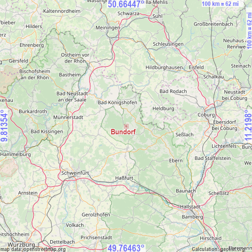
Bundorf GPS coordinates[2]
50° 13' 0.012" North, 10° 31' 0.012" East
| Map corner | latitude | longitude |
|---|---|---|
| Upper-left | 50.66447°, | 9.81354° |
| Center: | 50.21667°, | 10.51667° |
| Lower-right: | 49.76463°, | 11.2198° |
| Map W x H: | 100.1×100.1 km | = 62.2×62.2mi |
| max Lat: | 55.01917° ⇑58.8% North |
| Bundorf: | 50.21667° |
| min Lat: | ⇓41.2% South 47.40724° |
| min Long | Bundorf | max Long |
| 5.92978° | 10.51667° | 14.98853° |
| W 59.1%⇐ | ⇒40.9% E |
Elevation
Elevation of Bundorf is 325 m = 1066 ft, and this is 75.9 m = 249 ft above average elevation for this country.
| Max E: |
1256 m = 4121 ft | 34.5% |
| Bundorf | 325 m 1066 ft | |
| Avg. | 249.1 m = 817 ft | |
Min E: |
-5 m = -16 ft | 65.5% |
See also: Germany elevation on elevation.city.
Geographical zone
Bundorf is located in North temperate zone (between Tropic of Cancer and the Arctic Circle). Distance of this North polar circle is 1817.6 km =1129.4 mi to North.| Distance of | km | miles | from Bundorf |
|---|---|---|---|
| North Pole | 4423.5 | 2748.6 | to North |
| Arctic Circle | 1817.6 | 1129.4 | to North |
| Tropic Cancer | 2977.7 | 1850.3 | to South |
| Equator | 5583.6 | 3469.5 | to South |


Nearby cities:
15 places around Bundorf: (largest is in red/bold)
• Aidhausen
9.5 km =5.9 mi,  218°
218°
• Bad Königshofen im Grabfeld
10 km =6.2 mi,  340°
340°
• Burgpreppach
12.6 km =7.8 mi,  131°
131°
• Ermershausen
7.8 km =4.8 mi,  96°
96°
• Gompertshausen
11.9 km =7.4 mi,  40°
40°
• Großbardorf
12 km =7.5 mi,  297°
297°
• Großeibstadt
12.1 km =7.5 mi,  320°
320°
• Hellingen
12.4 km =7.7 mi,  72°
72°
• Herbstadt
13 km =8.1 mi,  354°
354°
• Hofheim in Unterfranken
8.9 km =5.5 mi,  177°
177°
• Maroldsweisach
10.5 km =6.5 mi, 102°
• Stadtlauringen
11.5 km =7.1 mi,  253°
253°
• Sulzfeld
9.3 km =5.8 mi, 301°
• Thundorf in Unterfranken
14.2 km =8.8 mi,  262°
262°
• Trappstadt
12 km =7.5 mi,  18°
18°
Sources, notices
• [Note1] Compared only with cities in Germany existing in our database
• [Src1] Map data: © OpenStreetMap contributors (CC-BY-SA)
• [Src2] Other city data from geonames.org with taken over terms of usage.
• [Src3] Geographical zone / Annual Mean Temperature by Robert A. Rohde @ Wikipedia
