Bad Königshofen im Grabfeld geodata
Bad Königshofen im Grabfeld (Bavaria) is a populated place; located in Germany in Europe/Berlin (GMT+2) time zone. With population of 7,066 people, there are 2168 cities with bigger population in this country. Compared to other cities in Germany, 56.7% of cities are located further ↑North; 58.4% of cities are located further ←West and 58.5% of cities have lower elevation than Bad Königshofen im Grabfeld. Note1
Administrative division(s):
- Level 1: Bavaria
- Level 2: Regierungsbezirk Unterfranken
- Level 3: Landkreis Rhön-Grabfeld
- Level 4: Bad Königshofen i.Grabfeld
Current local time in Bad Königshofen im Grabfeld:
06:00 PM, FridayDifference from your time zone: hours


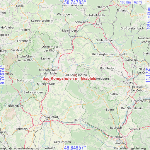
Bad Königshofen im Grabfeld GPS coordinates[2]
50° 18' 2.952" North, 10° 28' 7.932" East
| Map corner | latitude | longitude |
|---|---|---|
| Upper-left | 50.74783°, | 9.76574° |
| Center: | 50.30082°, | 10.46887° |
| Lower-right: | 49.84957°, | 11.172° |
| Map W x H: | 99.9×99.9 km | = 62.1×62.1mi |
| max Lat: | 55.01917° ⇑56.7% North |
| Bad Königshofen im Grabfeld: | 50.30082° |
| min Lat: | ⇓43.3% South 47.40724° |
| min Long | Bad Königshofe | max Long |
| 5.92978° | 10.46887° | 14.98853° |
| W 58.4%⇐ | ⇒41.6% E |
Elevation
Elevation of Bad Königshofen im Grabfeld is 281 m = 922 ft, and this is 31.9 m = 105 ft above average elevation for this country.
| Max E: |
1256 m = 4121 ft | 41.5% |
| Bad Königshofen im Grabfeld | 281 m 922 ft | |
| Avg. | 249.1 m = 817 ft | |
Min E: |
-5 m = -16 ft | 58.5% |
See also: Germany elevation on elevation.city.
Geographical zone
Bad Königshofen im Grabfeld is located in North temperate zone (between Tropic of Cancer and the Arctic Circle). Distance of this North polar circle is 1808.2 km =1123.6 mi to North.| Distance of | km | miles | from Bad Königshofen im Grabfeld |
|---|---|---|---|
| North Pole | 4414.1 | 2742.8 | to North |
| Arctic Circle | 1808.2 | 1123.6 | to North |
| Tropic Cancer | 2987 | 1856 | to South |
| Equator | 5592.9 | 3475.3 | to South |


Nearby cities:
15 places around Bad Königshofen im Grabfeld: (largest is in red/bold)
• Aubstadt
4.4 km =2.7 mi,  325°
325°
• Behrungen
12.8 km =8 mi,  342°
342°
• Bundorf
10 km =6.2 mi,  160°
160°
• Gleichamberg
12 km =7.5 mi,  49°
49°
• Gompertshausen
11.1 km =6.9 mi,  91°
91°
• Großbardorf
8.2 km =5.1 mi,  242°
242°
• Großeibstadt
4.2 km =2.6 mi,  270°
270°
• Herbstadt
4.2 km =2.6 mi,  31°
31°
• Höchheim
7.4 km =4.6 mi,  349°
349°
• Milz
9.8 km =6.1 mi, 29°
• Römhild
11.7 km =7.3 mi, 25°
• Saal an der Saale
8.1 km =5 mi,  282°
282°
• Sulzfeld
6.4 km =4 mi,  224°
224°
• Trappstadt
7.5 km =4.7 mi,  74°
74°
• Wülfershausen
9.7 km =6 mi,  290°
290°
Sources, notices
• [Note1] Compared only with cities in Germany existing in our database
• [Src1] Map data: © OpenStreetMap contributors (CC-BY-SA)
• [Src2] Other city data from geonames.org with taken over terms of usage.
• [Src3] Geographical zone / Annual Mean Temperature by Robert A. Rohde @ Wikipedia
