Gröbenzell geodata
Gröbenzell (Bavaria) is a seat of a fourth-order administrative division; located in Germany in Europe/Berlin (GMT+2) time zone. With population of 19,110 people, there are 819 cities with bigger population in this country. Compared to other cities in Germany, 92.7% of cities are located further ↑North; 72.2% of cities are located further ←West and 89.4% of cities have lower elevation than Gröbenzell. Note1
Administrative division(s):
- Level 1: Bavaria
- Level 2: Upper Bavaria
- Level 3: Landkreis Fürstenfeldbruck
- Level 4: Gröbenzell


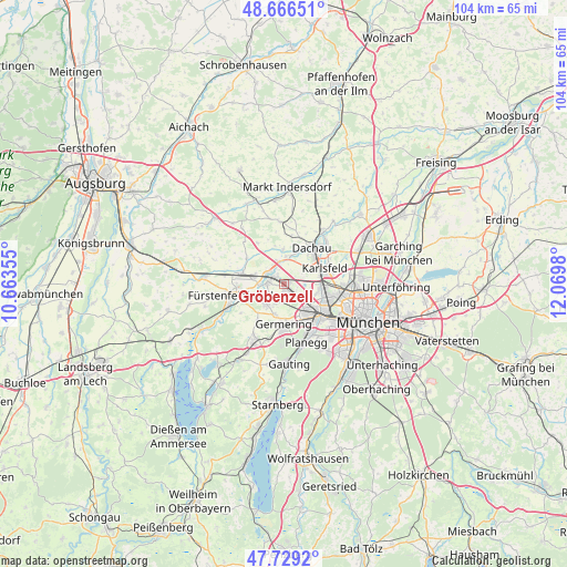
Gröbenzell GPS coordinates[2]
48° 12' 0" North, 11° 22' 0.012" East
| Map corner | latitude | longitude |
|---|---|---|
| Upper-left | 48.66651°, | 10.66355° |
| Center: | 48.2°, | 11.36667° |
| Lower-right: | 47.7292°, | 12.0698° |
| Map W x H: | 104.2×104.2 km | = 64.7×64.7mi |
| max Lat: | 55.01917° ⇑92.7% North |
| Gröbenzell: | 48.2° |
| min Lat: | ⇓7.3% South 47.40724° |
| min Long | Gröbenzell | max Long |
| 5.92978° | 11.36667° | 14.98853° |
| W 72.2%⇐ | ⇒27.8% E |
Elevation
Elevation of Gröbenzell is 507 m = 1663 ft, and this is 257.9 m = 846 ft above average elevation for this country.
| Max E: |
1256 m = 4121 ft | 10.6% |
| Gröbenzell | 507 m 1663 ft | |
| Avg. | 249.1 m = 817 ft | |
Min E: |
-5 m = -16 ft | 89.4% |
See also: Germany elevation on elevation.city.
Geographical zone
Gröbenzell is located in North temperate zone (between Tropic of Cancer and the Arctic Circle). Distance of this North polar circle is 2041.8 km =1268.7 mi to North.| Distance of | km | miles | from Gröbenzell |
|---|---|---|---|
| North Pole | 4647.7 | 2887.9 | to North |
| Arctic Circle | 2041.8 | 1268.7 | to North |
| Tropic Cancer | 2753.4 | 1710.9 | to South |
| Equator | 5359.3 | 3330.1 | to South |


Nearby cities:
15 places around Gröbenzell: (largest is in red/bold)
• Alling
8.2 km =5.1 mi,  216°
216°
• Bergkirchen
6.3 km =3.9 mi,  358°
358°
• Dachau
8.3 km =5.2 mi,  36°
36°
• Eichenau
5.2 km =3.2 mi,  225°
225°
• Emmering
6.4 km =4 mi,  253°
253°
• Fürstenfeldbruck
8.6 km =5.3 mi, 254°
• Germering
7.4 km =4.6 mi,  174°
174°
• Gräfelfing
10.2 km =6.3 mi,  152°
152°
• Karlsfeld
8.6 km =5.3 mi,  69°
69°
• Krailling
11.4 km =7.1 mi, 167°
• Maisach
7.6 km =4.7 mi,  284°
284°
• Olching
2.5 km =1.6 mi,  270°
270°
• Pasing
9.3 km =5.8 mi,  134°
134°
• Planegg
11.2 km =7 mi,  157°
157°
• Puchheim
5.7 km =3.5 mi,  192°
192°
Sources, notices
• [Note1] Compared only with cities in Germany existing in our database
• [Src1] Map data: © OpenStreetMap contributors (CC-BY-SA)
• [Src2] Other city data from geonames.org with taken over terms of usage.
• [Src3] Geographical zone / Annual Mean Temperature by Robert A. Rohde @ Wikipedia
