Karlsfeld geodata
Karlsfeld (Bavaria) is a seat of a fourth-order administrative division; located in Germany in Europe/Berlin (GMT+2) time zone. With population of 17,920 people, there are 883 cities with bigger population in this country. Compared to other cities in Germany, 92.3% of cities are located further ↑North; 73.9% of cities are located further ←West and 87.3% of cities have lower elevation than Karlsfeld. Note1
Administrative division(s):
- Level 1: Bavaria
- Level 2: Upper Bavaria
- Level 3: Landkreis Dachau
- Level 4: Karlsfeld


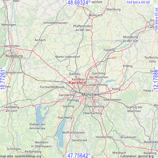
Karlsfeld GPS coordinates[2]
48° 13' 37.092" North, 11° 28' 32.628" East
| Map corner | latitude | longitude |
|---|---|---|
| Upper-left | 48.69324°, | 10.77261° |
| Center: | 48.22697°, | 11.47573° |
| Lower-right: | 47.75642°, | 12.17886° |
| Map W x H: | 104.2×104.2 km | = 64.7×64.7mi |
| max Lat: | 55.01917° ⇑92.3% North |
| Karlsfeld: | 48.22697° |
| min Lat: | ⇓7.7% South 47.40724° |
| min Long | Karlsfeld | max Long |
| 5.92978° | 11.47573° | 14.98853° |
| W 73.9%⇐ | ⇒26.1% E |
Elevation
Elevation of Karlsfeld is 488 m = 1601 ft, and this is 238.9 m = 784 ft above average elevation for this country.
| Max E: |
1256 m = 4121 ft | 12.7% |
| Karlsfeld | 488 m 1601 ft | |
| Avg. | 249.1 m = 817 ft | |
Min E: |
-5 m = -16 ft | 87.3% |
See also: Germany elevation on elevation.city.
Geographical zone
Karlsfeld is located in North temperate zone (between Tropic of Cancer and the Arctic Circle). Distance of this North polar circle is 2038.8 km =1266.9 mi to North.| Distance of | km | miles | from Karlsfeld |
|---|---|---|---|
| North Pole | 4644.7 | 2886.1 | to North |
| Arctic Circle | 2038.8 | 1266.9 | to North |
| Tropic Cancer | 2756.4 | 1712.7 | to South |
| Equator | 5362.3 | 3332 | to South |


Nearby cities:
15 places around Karlsfeld: (largest is in red/bold)
• Bergkirchen
8.8 km =5.5 mi,  291°
291°
• Dachau
4.8 km =3 mi,  319°
319°
• Germering
12.7 km =7.9 mi,  215°
215°
• Gräfelfing
12.5 km =7.8 mi,  195°
195°
• Gröbenzell
8.6 km =5.3 mi,  249°
249°
• Haimhausen
11.4 km =7.1 mi,  30°
30°
• Hebertshausen
7 km =4.3 mi,  353°
353°
• Munich
12.4 km =7.7 mi,  143°
143°
• Oberschleißheim
7.2 km =4.5 mi,  69°
69°
• Olching
11 km =6.8 mi, 254°
• Pasing
9.6 km =6 mi,  188°
188°
• Puchheim
12.7 km =7.9 mi,  227°
227°
• Röhrmoos
11.6 km =7.2 mi, 349°
• Schwabhausen
12.3 km =7.6 mi,  313°
313°
• Unterschleißheim
9.6 km =6 mi,  51°
51°
Sources, notices
• [Note1] Compared only with cities in Germany existing in our database
• [Src1] Map data: © OpenStreetMap contributors (CC-BY-SA)
• [Src2] Other city data from geonames.org with taken over terms of usage.
• [Src3] Geographical zone / Annual Mean Temperature by Robert A. Rohde @ Wikipedia
