Schaufling geodata
Schaufling (Bavaria) is a seat of a fourth-order administrative division; located in Germany in Europe/Berlin (GMT+2) time zone. With population of 1,494 people, there are 5892 cities with bigger population in this country. Compared to other cities in Germany, 84.7% of cities are located further ↑North; 92.7% of cities are located further ←West and 88.1% of cities have lower elevation than Schaufling. Note1
Administrative division(s):
- Level 1: Bavaria
- Level 2: Lower Bavaria
- Level 3: Landkreis Deggendorf
- Level 4: Schaufling


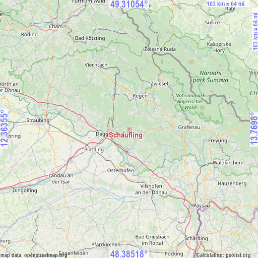
Schaufling GPS coordinates[2]
48° 51' 0" North, 13° 4' 0.012" East
| Map corner | latitude | longitude |
|---|---|---|
| Upper-left | 49.31054°, | 12.36355° |
| Center: | 48.85°, | 13.06667° |
| Lower-right: | 48.38518°, | 13.7698° |
| Map W x H: | 102.9×102.9 km | = 63.9×63.9mi |
| max Lat: | 55.01917° ⇑84.7% North |
| Schaufling: | 48.85° |
| min Lat: | ⇓15.3% South 47.40724° |
| min Long | Schaufling | max Long |
| 5.92978° | 13.06667° | 14.98853° |
| W 92.7%⇐ | ⇒7.3% E |
Elevation
Elevation of Schaufling is 495 m = 1624 ft, and this is 245.9 m = 807 ft above average elevation for this country.
| Max E: |
1256 m = 4121 ft | 11.9% |
| Schaufling | 495 m 1624 ft | |
| Avg. | 249.1 m = 817 ft | |
Min E: |
-5 m = -16 ft | 88.1% |
See also: Germany elevation on elevation.city.
Geographical zone
Schaufling is located in North temperate zone (between Tropic of Cancer and the Arctic Circle). Distance of this North polar circle is 1969.6 km =1223.9 mi to North.| Distance of | km | miles | from Schaufling |
|---|---|---|---|
| North Pole | 4575.5 | 2843.1 | to North |
| Arctic Circle | 1969.6 | 1223.9 | to North |
| Tropic Cancer | 2825.7 | 1755.8 | to South |
| Equator | 5431.6 | 3375 | to South |


Nearby cities:
15 places around Schaufling: (largest is in red/bold)
• Auerbach
5.7 km =3.5 mi,  155°
155°
• Bischofsmais
7.6 km =4.7 mi,  8°
8°
• Deggendorf
7.8 km =4.8 mi,  262°
262°
• Grafling
8.4 km =5.2 mi,  306°
306°
• Grattersdorf
8.2 km =5.1 mi,  128°
128°
• Hengersberg
8.7 km =5.4 mi,  185°
185°
• Hunding
8.1 km =5 mi,  96°
96°
• Kirchberg
10.1 km =6.3 mi,  56°
56°
• Lalling
5.4 km =3.4 mi, 95°
• Metten
11.1 km =6.9 mi,  272°
272°
• Moos
13.4 km =8.3 mi,  215°
215°
• Niederalteich
9.9 km =6.2 mi,  198°
198°
• Schöfweg
11.9 km =7.4 mi, 95°
• Schöllnach
13.4 km =8.3 mi,  142°
142°
• Zachenberg
13.9 km =8.6 mi,  339°
339°
Sources, notices
• [Note1] Compared only with cities in Germany existing in our database
• [Src1] Map data: © OpenStreetMap contributors (CC-BY-SA)
• [Src2] Other city data from geonames.org with taken over terms of usage.
• [Src3] Geographical zone / Annual Mean Temperature by Robert A. Rohde @ Wikipedia
